For more frequent updates visit my weather Facebook page - click here and hit like at the top of the page.

This blog is best viewed with Mozilla Firefox. There could be issues with spacing on Internet Explorer

.
Here are my current personal forecast thoughts for far southern Illinois and western Kentucky...
Friday: Mostly sunny and hot. A chance for a few thunderstorms during the later afternoon hours - storms becoming more likely later this evening. A few severe storms will be possible. To view watches and warnings - click here for the National Weather Service
Wind: Southerly winds at 10-20 mph - gusty near storms
Precipitation probability - 40% | Rainfall totals: scattered 0.25"-0.50" with locally heavier amounts in thunderstorms
Confidence in this forecast is very high
Forecast for your local town/city - Click Here
Wind: Southwest winds at 10-15 mph becoming northwest late at 10-20 mph and gusty at times
Precipitation probability - 80%-100% | Rainfall totals: scattered 0.25"-0.50" locally heavier in thunderstorms - some areas could see over 1" of rain.
Confidence in this forecast is very high
Wind: Northerly/northwestly winds at 10-20 mph with gusts to 30 mph
Precipitation probability - 20% | Rainfall totals: 0.10"
Confidence in this forecast is medium
Above normal temperatures
Highs: in the upper 80s to lower 90s | Normal highs for this time of the year are around 83 degrees.Wind: Southerly winds at 10-20 mph - gusty near storms
Precipitation probability - 40% | Rainfall totals: scattered 0.25"-0.50" with locally heavier amounts in thunderstorms
Confidence in this forecast is very high
Forecast for your local town/city - Click Here
Friday night: Cloudy with showers and heavy thunderstorms. Some storms will be severe with high winds and hail. Isolated tornadoes possible. To view watches and warnings - click here for the National Weather Service
Near normal temperatures
Lows: in the middle 60s | Normal lows for this time of the year are around 61 degrees.Wind: Southwest winds at 10-15 mph becoming northwest late at 10-20 mph and gusty at times
Precipitation probability - 80%-100% | Rainfall totals: scattered 0.25"-0.50" locally heavier in thunderstorms - some areas could see over 1" of rain.
Confidence in this forecast is very high
.
Saturday: Mostly cloudy with a chance for a few showers in the morning - becoming partly sunny. Cooler.and windy at times
Below normal temperatures
Highs: in the middle 70s | Normal highs for this time of the year are around 83 degrees.Below normal temperatures
Wind: Northerly/northwestly winds at 10-20 mph with gusts to 30 mph
Precipitation probability - 20% | Rainfall totals: 0.10"
Confidence in this forecast is medium
Saturday night: Mostly clear and cooler.
Below normal temperatures
Below normal temperatures
Lows: in the 52-56 range | Normal lows for this time of the year are around 61 degrees.
Wind: Northwest at 5-10 mph
Precipitation probability - 0% | Rainfall totals: isolated/scattered 0"
Confidence in this forecast is very high
Forecast for your local town/city - Click Here

This
forecast
analysis covers far southern
Illinois, southeast
Missouri,
southwest Indiana,
western Kentucky, and
northwest
Tennessee
HEADLINES: I totally missed the forecast on Thursday - thunderstorms formed over southeast Missouri and spread east into parts of Illinois and Kentucky. I guess I was paying too much attention to the Friday event. I didn't realize how bad the Thursday evening storms would be until around 1 or 2 pm in the afternoon - while in Paducah. Way too late for my taste. A 12 hour forecast - busted that bad? Unacceptable. It is what it is - will do better on the next one.
The rest of this discussion is about Friday and Saturday. See the Facebook page if you want updates on Thursday evening weather.
To view watches and warnings - click here for the National Weather Service
A strong cold front will approach our region on Friday and Friday night. This cold front will help spark widespread showers and thunderstorms over the region by Friday afternoon into the overnight hours. Football games may have to deal with thunderstorms in the area.
Numerous thunderstorms will produce heavy rain and frequent lightning. High winds and hail will be another concern. Some storms will be severe on Friday afternoon and evening. Remember a severe thunderstorm is one that produces 1" size hail and/or 58 mph winds and/or a tornado. There could be a few tornadoes on Friday afternoon/evening - monitor updates.
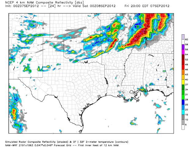
Here is what one model is showing for Friday afternoon and evening. This is a FUTURE-CAST radar image. That means it is showing you what radar MIGHT look like around 5 pm through 8 pm on Friday evening. Football games - take note!
Click image for real size view

Here is the high resolution
These images represent what the high resolution NAM model is forecasting for Friday afternoon into the evening hours - say from 2 or 3 pm through 8 or 9 pm. Again - timing could be off a bit - you get the idea. A strong/severe line of storms is likely to impact the region on Friday afternoon/evening.
Click images for the full size view of these maps


Zoomed in - early evening hours. Powerful line of storms
The PWAT values on Friday will be very high in our region - that means there will be a lot of moist and unstable air to work with. Thunderstorms could produce heavy rainfall in a short amount of time.
Here is a map from the high resolution NAM model - high PWAT values ahead of the cold front

Rainfall totals from the next storm system should be in the 0.25"-0.75" range with pockets of heavier amounts. Would not be surprised to see some 1-2" amounts from the heaviest storms.
Let's take a look at some of the severe weather parameters that forecasters use to forecast severe thunderstorms. These images are from www.wright-weather.com
First let's take a look at CAPE. CAPE basically - in a nutshell - tells you how much energy is available in the atmosphere. I like to look for 1000-3000 CAPE numbers (this time of the year). Models indicate that there will be enough instability tomorrow for concern. Values are ranging from 2000 to 4000 (even higher on some of the data). Part of the CAPE forecast will depend on cloud cover tomorrow morning. This will need to be monitored.
I am a little concerned about tonight's activity (Thursday night) laying down a boundary somewhere in the region. Boundaries can cause enhanced areas of wind shear - something I monitor for tornado activity. Tornado risk appears low on Friday - but there could be a few tornado warnings if things come together just right. Monitor, as always.
Click image for real size view
 Next let's take a look at lift index values. They will be very low tomorrow. Anytime you see negative lift index values then we know thunderstorms will be possible. Lift index values on some of the data are indicating anywhere from -2 to -11
Click image for real size view
 Next image - below - is the EHI numbers. I look for EHI when I start forecasting tornadoes - one of the parameters. EHI values of 1 to 3 indicate some tornado potential - or higher. There are a lot of other parameters that must come together to forecast tornadoes (this is just one of them). We see some enhanced numbers associated with the line of storms on Friday afternoon and evening.
Again - click image for real size view
 Finally - this map shows you the vertical velocities tomorrow afternoon - that is sexy weather talk! Vertical velocities are basically LIFT - imagine a box of air being lifted higher and higher into the atmosphere. You have to have lift in order to have thunderstorm development. You can see the lift and higher relative humidity levels along the front - that line of whitish colors. That is indicating the potential for a squall line - perhaps some supercells, as well.

And for you real weather geeks :) - here is the BUFKIT profile for Paducah (early tomorrow afternoon)
Click to view the image and details

WRAP IT ALL UP FOR ME!
Okay - bottom line:
A line of thunderstorms will form on Friday afternoon across portions of Illinois down into Missouri. This line of thunderstorms will intensify and shift east/southeast during the late afternoon and evening hours.
The line will move through southwest Indiana and far southern Illinois into western Kentucky and western Tennessee between 2 pm and 9 pm. The further northwest you are in the region the earlier the storms will arrive. The further southeast you are in the area (Murray/Kentucky Lake/Hopkinsville) the later in the evening it will be.
Some storms may form ahead of the line.
I will fine tune the timing part of the forecast (here on the blog and on Facebook) on Friday morning. If the front slows down then the timing will be off.
Supercells that form ahead of the line could throw the timing off - so monitor for updates.
A tornado and/or a severe thunderstorm watch (several actually) will likely be issued on Friday afternoon and evening for our area.
Severe thunderstorm warnings are likely on Friday afternoon and evening in some of our counties. I expect some wind gusts over 60 mph from the most intense storms. I suspect there will be a few reports of large hail, as well. Tornadoes can't be ruled out. Monitor updates closely on Friday afternoon and evening.
Outdoor sporting events should pay special attention to the latest storm updates.
As always it is meteorologically impossible to forecast what areas will receive actual severe weather. Monitor warnings as they are issued.
Rainfall totals by Saturday morning should range from 0.50-1.00" - locally heavier amounts likely in the heaviest thunderstorms. Would not be surprised to see some 1-2" reports from the heaviest thunderstorm cells.
To view watches and warnings - click here for the National Weather Service
A few lingering showers will be possible Saturday morning.
Much cooler air will filter in behind the cold front for the weekend. Breezy conditions on Friday night and Saturday with highs in the 70s. Highs on Sunday will also be in the 70s. Overnight lows will be in the 50s. I would not be surprised to see some 40s over parts of Missouri and Illinois.
Here are the high temperatures for Saturday and Sunday - feel the fall in the air? At least a little!

 The tropics are active - you can monitor the tropics by clicking here.
Leslie is going to impact Bermuda - quite hard. High winds and heavy swells likely on the island. Could be quite a bit of damage from this one.

Leslie and Michael are both going strong - here are some satellite images of them (click for real size - large views)

And Michael (below)

Neither of these systems are going to impact the United States directly. They will cause high swells on the east coast. They will also have major influences on the overall weather pattern for North America over the coming weeks.
Wind: Northwest at 5-10 mph
Precipitation probability - 0% | Rainfall totals: isolated/scattered 0"
Confidence in this forecast is very high
Forecast for your local town/city - Click Here
HEADLINES: I totally missed the forecast on Thursday - thunderstorms formed over southeast Missouri and spread east into parts of Illinois and Kentucky. I guess I was paying too much attention to the Friday event. I didn't realize how bad the Thursday evening storms would be until around 1 or 2 pm in the afternoon - while in Paducah. Way too late for my taste. A 12 hour forecast - busted that bad? Unacceptable. It is what it is - will do better on the next one.
The rest of this discussion is about Friday and Saturday. See the Facebook page if you want updates on Thursday evening weather.
To view watches and warnings - click here for the National Weather Service
A strong cold front will approach our region on Friday and Friday night. This cold front will help spark widespread showers and thunderstorms over the region by Friday afternoon into the overnight hours. Football games may have to deal with thunderstorms in the area.
Numerous thunderstorms will produce heavy rain and frequent lightning. High winds and hail will be another concern. Some storms will be severe on Friday afternoon and evening. Remember a severe thunderstorm is one that produces 1" size hail and/or 58 mph winds and/or a tornado. There could be a few tornadoes on Friday afternoon/evening - monitor updates.
Here is what one model is showing for Friday afternoon and evening. This is a FUTURE-CAST radar image. That means it is showing you what radar MIGHT look like around 5 pm through 8 pm on Friday evening. Football games - take note!
Click image for real size view

Here is the high resolution
These images represent what the high resolution NAM model is forecasting for Friday afternoon into the evening hours - say from 2 or 3 pm through 8 or 9 pm. Again - timing could be off a bit - you get the idea. A strong/severe line of storms is likely to impact the region on Friday afternoon/evening.
Click images for the full size view of these maps


Zoomed in - early evening hours. Powerful line of storms

The PWAT values on Friday will be very high in our region - that means there will be a lot of moist and unstable air to work with. Thunderstorms could produce heavy rainfall in a short amount of time.
Here is a map from the high resolution NAM model - high PWAT values ahead of the cold front

Rainfall totals from the next storm system should be in the 0.25"-0.75" range with pockets of heavier amounts. Would not be surprised to see some 1-2" amounts from the heaviest storms.
Let's take a look at some of the severe weather parameters that forecasters use to forecast severe thunderstorms. These images are from www.wright-weather.com
First let's take a look at CAPE. CAPE basically - in a nutshell - tells you how much energy is available in the atmosphere. I like to look for 1000-3000 CAPE numbers (this time of the year). Models indicate that there will be enough instability tomorrow for concern. Values are ranging from 2000 to 4000 (even higher on some of the data). Part of the CAPE forecast will depend on cloud cover tomorrow morning. This will need to be monitored.
I am a little concerned about tonight's activity (Thursday night) laying down a boundary somewhere in the region. Boundaries can cause enhanced areas of wind shear - something I monitor for tornado activity. Tornado risk appears low on Friday - but there could be a few tornado warnings if things come together just right. Monitor, as always.
Click image for real size view

Click image for real size view

Again - click image for real size view


And for you real weather geeks :) - here is the BUFKIT profile for Paducah (early tomorrow afternoon)
Click to view the image and details

WRAP IT ALL UP FOR ME!
Okay - bottom line:
A line of thunderstorms will form on Friday afternoon across portions of Illinois down into Missouri. This line of thunderstorms will intensify and shift east/southeast during the late afternoon and evening hours.
The line will move through southwest Indiana and far southern Illinois into western Kentucky and western Tennessee between 2 pm and 9 pm. The further northwest you are in the region the earlier the storms will arrive. The further southeast you are in the area (Murray/Kentucky Lake/Hopkinsville) the later in the evening it will be.
Some storms may form ahead of the line.
I will fine tune the timing part of the forecast (here on the blog and on Facebook) on Friday morning. If the front slows down then the timing will be off.
Supercells that form ahead of the line could throw the timing off - so monitor for updates.
A tornado and/or a severe thunderstorm watch (several actually) will likely be issued on Friday afternoon and evening for our area.
Severe thunderstorm warnings are likely on Friday afternoon and evening in some of our counties. I expect some wind gusts over 60 mph from the most intense storms. I suspect there will be a few reports of large hail, as well. Tornadoes can't be ruled out. Monitor updates closely on Friday afternoon and evening.
Outdoor sporting events should pay special attention to the latest storm updates.
As always it is meteorologically impossible to forecast what areas will receive actual severe weather. Monitor warnings as they are issued.
Rainfall totals by Saturday morning should range from 0.50-1.00" - locally heavier amounts likely in the heaviest thunderstorms. Would not be surprised to see some 1-2" reports from the heaviest thunderstorm cells.
To view watches and warnings - click here for the National Weather Service
A few lingering showers will be possible Saturday morning.
Much cooler air will filter in behind the cold front for the weekend. Breezy conditions on Friday night and Saturday with highs in the 70s. Highs on Sunday will also be in the 70s. Overnight lows will be in the 50s. I would not be surprised to see some 40s over parts of Missouri and Illinois.
Here are the high temperatures for Saturday and Sunday - feel the fall in the air? At least a little!
Leslie is going to impact Bermuda - quite hard. High winds and heavy swells likely on the island. Could be quite a bit of damage from this one.
Leslie and Michael are both going strong - here are some satellite images of them (click for real size - large views)

And Michael (below)

Neither of these systems are going to impact the United States directly. They will cause high swells on the east coast. They will also have major influences on the overall weather pattern for North America over the coming weeks.

Thunderstorms on Friday into Friday night could produce a few reports of severe weather. Right now the primary concern appears to be lightning, high winds, and possibly some hail. Isolated tornado threat if things come together just right.
Monitor for possible watches and warnings on Friday.
Friday night football games will have to deal with thunderstorms.

Yes - monitor for possible watches and warnings on Friday afternoon/Friday night.

No wild cards in this update
.
.

.
No major changes since the last update
.

.
Forecast for your local town/city - Click Here
.
..
Join me on Facebook for more frequent updates on the weather in our local areaClick Here . I also strongly encourage you to FRIEND some of the local media meteorologists - I follow all of them and so should you.
We have a TON of new weather maps on the Weather Observatory web-site - these include temperatures, wind speed, dew points, heat index, barometric pressure, predicted rainfall, climate forecast, medium and long range maps, forecasts and more! Click here
Don't forget to sign up for the severe weather "heads up" email list - I usually email everyone before a big event - severe weather - tornado outbreaks - winter storms - ice storms. Click here to join
.
---

The forecast for severe or extreme weather
.
The McCracken County Office of Emergency Management reminds you that owning a NOAA All Hazards Weather Radio is the best way to receive notifications of severe weather watches and warnings.
.
Remember that the National Weather Service defines a severe thunderstorm as one that produces 58 mph winds or higher, hail 1" in size or larger, and/or a tornado.
Friday: A few severe storms likely. No snow or ice.
Friday: Will there be a chance for non-severe thunderstorms? Thunderstorms will be possible
Friday night: A few severe thunderstorms likely. No snow or ice.
Friday night: Will there be a chance for non-severe thunderstorms? Thunderstorms will be possible
Saturday: Severe weather is not anticipated. No snow or ice.
Saturday: Will there be a chance for non-severe thunderstorms? No
.
Saturday night : Severe weather is not anticipated. No snow or ice.
Saturday night: Will there be a chance for non-severe thunderstorms? No
.
For the most up to date severe weather outlooks - click here.
For the most up to date severe weather outlooks - click here.
or
Visit the Storm Prediction Center's web-site - click here
To view storm reports from today and yesterday - click here
.
 .
.
Will the Storm Prediction Center issue a tornado or severe thunderstorm watch for southeast Missouri, southern Illinois, or western Kentucky?
Friday - Likely
Friday night - Likely
Saturday - No
Saturday night No
To view the official Storm Prediction Center's web-site - click here Alternative link - click here
To view storm reports from today and yesterday - click here
.
Will the Storm Prediction Center issue a tornado or severe thunderstorm watch for southeast Missouri, southern Illinois, or western Kentucky?
Friday - Likely
Friday night - Likely
Saturday - No
Saturday night No
To view the official Storm Prediction Center's web-site - click here Alternative link - click here

.
To view all watches and warnings in IL - Click Here
To view all watches and warnings in KY - Click Here
To view all watches and warnings in MO - Click Here
To view all watches and warnings in TN - Click Here
All other states- Click Here
To view all watches and warnings in IL - Click Here
To view all watches and warnings in KY - Click Here
To view all watches and warnings in MO - Click Here
To view all watches and warnings in TN - Click Here
All other states- Click Here
.
The
links above are interactive and
you can move
around the United States by
simply clicking on the
national map - or
from the pull down menu
where it says regions and
US States.
.
To view the interactive warning map - click here.
.
 .
.
You can listen to local emergency services, SKYWARN storm spotters, and more by visiting our scanner feed page - click here
.
 .
.
The Weather Observatory is a strong partner with the National Weather Service - click here to visit your local NWS web-site. For the most up to date warnings/advisories hit refresh on their page.
 .
.
We have a number of new radars available on our Weather Observatory web-site !
---
We now offer St Louis, Mt Vernon, Evansville, Poplar Bluff, Cape Girardeau, Marion, Paducah, Hopkinsville, and Dyersburg Interactive City Radars. We also have the two regional radars and now offer you three GR Earth radars.
Click here for our radar page - WEATHER RADARS ---
---
We also have a new interactive radar - you can view that radar by clicking here.
.
To view the interactive warning map - click here.
.
You can listen to local emergency services, SKYWARN storm spotters, and more by visiting our scanner feed page - click here
.
The Weather Observatory is a strong partner with the National Weather Service - click here to visit your local NWS web-site. For the most up to date warnings/advisories hit refresh on their page.
. We have a number of new radars available on our Weather Observatory web-site !
---
We now offer St Louis, Mt Vernon, Evansville, Poplar Bluff, Cape Girardeau, Marion, Paducah, Hopkinsville, and Dyersburg Interactive City Radars. We also have the two regional radars and now offer you three GR Earth radars.
Click here for our radar page - WEATHER RADARS ---
---
We also have a new interactive radar - you can view that radar by clicking here.
.
Want to learn more about how to use our radars? I made a how to video with more information
Click here - http://www.youtube.com/watch?v=bfLa0hI3adU
.
.
-----------------------------
.

.
Let's
check
out the how much rain is
forecast to fall
over the next 48
hours. This map gives
you a general
broad brushed idea of
what can be
expected. Remember the scale is at the top of the map.
.
If you would like to view the most up to date 24, 48, 72, and 120 hour precipitation forecast maps then click here.

.
If you would like to view the most up to date 24, 48, 72, and 120 hour precipitation forecast maps then click here.

.
You can also now view the probability of X amount of rain (you pick the value on the web-site) in a six hour period of time. Those maps can be viewed here.
.

Current conditions - including temperatures, apparent temperatures, heat index, wind chill, wind, pressure, humidity, dew points, and more - click here
.
You can also now view the probability of X amount of rain (you pick the value on the web-site) in a six hour period of time. Those maps can be viewed here.
.
Current conditions - including temperatures, apparent temperatures, heat index, wind chill, wind, pressure, humidity, dew points, and more - click here
.

.
You can view the upcoming days high temperature and low temperature forecasts by clicking here - choose the day - click on your state to zoom in
.
To view recent records that have been broken - click here
.
.
You can view the upcoming days high temperature and low temperature forecasts by clicking here - choose the day - click on your state to zoom in
.
To view recent records that have been broken - click here
.
.
---

1. Much cooler weather on Saturday and Sunday. It will be windy at times on Saturday - gusts in the 20-30 mph range possible (northerly). If you will be boating then pay a little more attention to wind forecast.
Temperatures on both Saturday and Sunday will be in the 70s! Overnight lows will dip into the 50s. Jacket weather?
Another weather story in the coming days will likely be Hurricane Leslie. She will move towards Bermuda - could produce a lot of damage on the island. The system may eventually impact Canada. Leslie could cause quite a few changes in the overall weather pattern for portions of Canada and the United States.
Latest drought information:
DROUGHT INFORMATION - CLICK HERE
Seasonal outlooks can be viewed on the web-site - click here
If you are a weather enthusiast then I recommend listening to WeatherBrains each week! For a more in-depth look at what is happening in meteorology.

Now is a GREAT
time to buy a NOAA All Hazards
Weather Radio. Better to have one
before storms
strike than to be without one
during an event. I recommend the
Midland Model 300 NOAA All Hazards Weather Radio - that is what I use here at my house!
.
Meteorologist Beau DodsonMcCracken County Office of Emergency Management
.
.
Beau Dodson Weather - Facebook
.

To view all watches and warnings in Illinois - Click Here
To view all watches and warnings in Kentucky - Click Here
To view all watches and warnings in Missouri - Click Here
To view all watches and warnings in Tennessee - Click Here
.
All other states- Click Here
.
For the latest watches and warnings please visit your local National Weather Service Office web-site.
http://www.weather.gov/organization.php
.
Remember most of the maps on the blog can be viewed on Weather Observatory Web-Site
.

.
No comments:
Post a Comment