For more frequent updates visit my weather Facebook page - click here and hit like at the top of the page.

This blog is best viewed with Mozilla Firefox. There could be issues with spacing on Internet Explorer

.
Here are my current personal forecast thoughts for far southern Illinois and western Kentucky...
Wednesday: Some morning fog possible - A chance for a morning shower or thunderstorm - then a chance for showers and thunderstorms during the afternoon hours. A few storms could be heavy - isolated severe storms possible. Warm and humid.
Wind: Southwest winds at 5-10 mph
Precipitation probability - 40%-60% with an 80% chance in our northern counties/northeast counties | Rainfall totals: scattered 0.25"-0.50"
Confidence in this forecast is very high
Forecast for your local town/city - Click Here
Wind: Southwest winds at 5-10 mph
Precipitation probability - 40%-60% mainly early | Rainfall totals: scattered 0.25"
Confidence in this forecast is very high
Wind: Northerly winds at 5 mph
Precipitation probability - 60% | Rainfall totals: isolated 0.25" - 0.50" locally heavier in storms
Confidence in this forecast is very high
Above normal temperatures
Highs: in the lower 90s | Normal highs for this time of the year are around 83 degrees.Wind: Southwest winds at 5-10 mph
Precipitation probability - 40%-60% with an 80% chance in our northern counties/northeast counties | Rainfall totals: scattered 0.25"-0.50"
Confidence in this forecast is very high
Forecast for your local town/city - Click Here
Wednesday night: Cloudy with a chance for a shower or thunderstorm early - then partly cloudy skies.
Above normal temperatures
Lows: in the upper 60s to lower 70s | Normal lows for this time of the year are around 61 degrees.Wind: Southwest winds at 5-10 mph
Precipitation probability - 40%-60% mainly early | Rainfall totals: scattered 0.25"
Confidence in this forecast is very high
.
Thursday: Partly sunny and warm for this time of the year - thunderstorms possible over southeast Missouri and southern Illinois. A few storms could become severe with hail and gusty winds.
Above normal temperatures
Highs: in the lower 90s | Normal highs for this time of the year are around 83 degrees.Above normal temperatures
Wind: Northerly winds at 5 mph
Precipitation probability - 60% | Rainfall totals: isolated 0.25" - 0.50" locally heavier in storms
Confidence in this forecast is very high
Thursday night: Thunderstorms likely early - then partly cloudy skies after midnight with a few remaining showers.
Above normal temperatures
Above normal temperatures
Lows: in the 65-68 | Normal lows for this time of the year are around 61 degrees.
Wind: Light and variable winds becoming northeast at 5-10 mph
Precipitation probability - 70% | Rainfall totals: isolated/scattered 0.25"-0.50" and locally heavier amounts in thunderstorms
Confidence in this forecast is medium
Forecast for your local town/city - Click Here

This
forecast
analysis covers far southern
Illinois, southeast
Missouri,
southwest Indiana,
western Kentucky, and
northwest
Tennessee
HEADLINES: A series of disturbances will move through the region over the coming days. The first one will arrive early on Wednesday morning followed by another one Wednesday afternoon. There will be a few showers and thunderstorms associated with the disturbance. Severe weather is not anticipated in our local counties.
A few of the storms will produce heavy rain, gusty winds, and possibly even hail. There is a risk for a few severe weather watches and warnings. Monitor watches/warnings if you have concerns as the day unfolds.
Here is the risk zone for Wednesday (orange is where a few severe storms could occur)

Temperatures will remain above normal through Thursday - highs in the 80s and 90s. Winds should not be much of a problem - if you are out boating.
Thunderstorms will be possible on Thursday afternoon - especially over southeast Missouri and parts of southern Illinois - western counties most likely.
A stronger storm system and cold front will enter the picture on Friday and Saturday - this system will likely bring a much better chance of showers and thunderstorms to our area. A few storms could be on the heavy side and isolated severe weather is possible.
Right now the Storm Prediction Center has NOT outlined a risk zone for Friday - this may change over the coming day or two - check back for updates.
Check out the rainfall totals from Isaac - portions of our region picked up anywhere from 1" right on towards 8-9". I said it all summer - we need a tropical system to help bring relief.
Click image for a LARGE view.

We are closing the books on "summer 2012" - did you think it was warmer than normal? Do ducks fly? :) YES - it was much warmer than normal. Click image for LARGE view.

And - as we look back at August. Here is the temperature and precipitation departures. It was sort of mixed for our region - nothing like June or July.


Also - a parting gift from Isaac. This is the moonlight view of Isaac as it was pounding the gulf coast.
Once again - click the image for the FULL size view.

According to NASA, the image was captured using the Visible Infrared Imaging Radiometer Suite (VIIRS), which detects light in a range of wavelengths. In this case, the clouds of Isaac were lit by moonlight, and the lights from the cities sparkled like diamonds
Wind: Light and variable winds becoming northeast at 5-10 mph
Precipitation probability - 70% | Rainfall totals: isolated/scattered 0.25"-0.50" and locally heavier amounts in thunderstorms
Confidence in this forecast is medium
Forecast for your local town/city - Click Here
HEADLINES: A series of disturbances will move through the region over the coming days. The first one will arrive early on Wednesday morning followed by another one Wednesday afternoon. There will be a few showers and thunderstorms associated with the disturbance. Severe weather is not anticipated in our local counties.
A few of the storms will produce heavy rain, gusty winds, and possibly even hail. There is a risk for a few severe weather watches and warnings. Monitor watches/warnings if you have concerns as the day unfolds.
Here is the risk zone for Wednesday (orange is where a few severe storms could occur)
Thunderstorms will be possible on Thursday afternoon - especially over southeast Missouri and parts of southern Illinois - western counties most likely.
A stronger storm system and cold front will enter the picture on Friday and Saturday - this system will likely bring a much better chance of showers and thunderstorms to our area. A few storms could be on the heavy side and isolated severe weather is possible.
Right now the Storm Prediction Center has NOT outlined a risk zone for Friday - this may change over the coming day or two - check back for updates.
Check out the rainfall totals from Isaac - portions of our region picked up anywhere from 1" right on towards 8-9". I said it all summer - we need a tropical system to help bring relief.
Click image for a LARGE view.

We are closing the books on "summer 2012" - did you think it was warmer than normal? Do ducks fly? :) YES - it was much warmer than normal. Click image for LARGE view.

And - as we look back at August. Here is the temperature and precipitation departures. It was sort of mixed for our region - nothing like June or July.
Also - a parting gift from Isaac. This is the moonlight view of Isaac as it was pounding the gulf coast.
Once again - click the image for the FULL size view.

According to NASA, the image was captured using the Visible Infrared Imaging Radiometer Suite (VIIRS), which detects light in a range of wavelengths. In this case, the clouds of Isaac were lit by moonlight, and the lights from the cities sparkled like diamonds

A few storms could reach severe limits today in parts of our area. Gusty winds and hail would be the main concern. Lightning, of course - is also possible. It appears a greater risk for severe weather will exist further north in Illinois and Indiana and into northern Kentucky. However, with that said - we will be in a risk zone today for a few severe storms across much of the region. Monitor watches and warnings if you have concerns.
Thursday - some storms in southeast Missouri and perhaps into southwest Illinois. Monitor radars - lightning, strong winds, and some hail with the heavier cells.

If you have outdoor sporting events then check radars on Wednesday. There will be a few thunderstorms scattered in the area.

No wild cards in this update
.
.

.
Updated severe weather risk and temperatures
.

.
Forecast for your local town/city - Click Here
.
..
Join me on Facebook for more frequent updates on the weather in our local areaClick Here . I also strongly encourage you to FRIEND some of the local media meteorologists - I follow all of them and so should you.
We have a TON of new weather maps on the Weather Observatory web-site - these include temperatures, wind speed, dew points, heat index, barometric pressure, predicted rainfall, climate forecast, medium and long range maps, forecasts and more! Click here
Don't forget to sign up for the severe weather "heads up" email list - I usually email everyone before a big event - severe weather - tornado outbreaks - winter storms - ice storms. Click here to join
.
---

The forecast for severe or extreme weather
.
The McCracken County Office of Emergency Management reminds you that owning a NOAA All Hazards Weather Radio is the best way to receive notifications of severe weather watches and warnings.
.
Remember that the National Weather Service defines a severe thunderstorm as one that produces 58 mph winds or higher, hail 1" in size or larger, and/or a tornado.
Wednesday: A few severe storms possible. No snow or ice.
Wednesday: Will there be a chance for non-severe thunderstorms? Thunderstorms will be possible on Wednesday and early Wednesday evening.
Wednesday night: A few severe storms possible early in the evening. No snow or ice.
Wednesday night: Will there be a chance for non-severe thunderstorms? A few storms early in the evening.
Thursday: Severe storms possible over southeast Missouri and perhaps southwest Illinois. No snow or ice.
Thursday: Will there be a chance for non-severe thunderstorms? Yes
.
Thursday night : Some severe storms possible in the area. No snow or ice.
Thursday night: Will there be a chance for non-severe thunderstorms? A chance for thunderstorms
.
For the most up to date severe weather outlooks - click here.
For the most up to date severe weather outlooks - click here.
or
Visit the Storm Prediction Center's web-site - click here
To view storm reports from today and yesterday - click here
.
 .
.
Will the Storm Prediction Center issue a tornado or severe thunderstorm watch for southeast Missouri, southern Illinois, or western Kentucky?
Wednesday - Yes - likely
Thursday - Yes
Friday - Possible watches
To view the official Storm Prediction Center's web-site - click here Alternative link - click here
To view storm reports from today and yesterday - click here
.
Will the Storm Prediction Center issue a tornado or severe thunderstorm watch for southeast Missouri, southern Illinois, or western Kentucky?
Wednesday - Yes - likely
Thursday - Yes
Friday - Possible watches
To view the official Storm Prediction Center's web-site - click here Alternative link - click here

.
To view all watches and warnings in IL - Click Here
To view all watches and warnings in KY - Click Here
To view all watches and warnings in MO - Click Here
To view all watches and warnings in TN - Click Here
All other states- Click Here
To view all watches and warnings in IL - Click Here
To view all watches and warnings in KY - Click Here
To view all watches and warnings in MO - Click Here
To view all watches and warnings in TN - Click Here
All other states- Click Here
.
The
links above are interactive and
you can move
around the United States by
simply clicking on the
national map - or
from the pull down menu
where it says regions and
US States.
.
To view the interactive warning map - click here.
.
 .
.
You can listen to local emergency services, SKYWARN storm spotters, and more by visiting our scanner feed page - click here
.
 .
.
The Weather Observatory is a strong partner with the National Weather Service - click here to visit your local NWS web-site. For the most up to date warnings/advisories hit refresh on their page.
 .
.
We have a number of new radars available on our Weather Observatory web-site !
---
We now offer St Louis, Mt Vernon, Evansville, Poplar Bluff, Cape Girardeau, Marion, Paducah, Hopkinsville, and Dyersburg Interactive City Radars. We also have the two regional radars and now offer you three GR Earth radars.
Click here for our radar page - WEATHER RADARS ---
---
We also have a new interactive radar - you can view that radar by clicking here.
.
To view the interactive warning map - click here.
.
You can listen to local emergency services, SKYWARN storm spotters, and more by visiting our scanner feed page - click here
.
The Weather Observatory is a strong partner with the National Weather Service - click here to visit your local NWS web-site. For the most up to date warnings/advisories hit refresh on their page.
. We have a number of new radars available on our Weather Observatory web-site !
---
We now offer St Louis, Mt Vernon, Evansville, Poplar Bluff, Cape Girardeau, Marion, Paducah, Hopkinsville, and Dyersburg Interactive City Radars. We also have the two regional radars and now offer you three GR Earth radars.
Click here for our radar page - WEATHER RADARS ---
---
We also have a new interactive radar - you can view that radar by clicking here.
.
Want to learn more about how to use our radars? I made a how to video with more information
Click here - http://www.youtube.com/watch?v=bfLa0hI3adU
.
.
-----------------------------
.

.
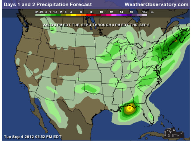
Let's
check
out the how much rain is
forecast to fall
over the next 48
hours. This map gives
you a general
broad brushed idea of
what can be
expected. Remember the scale is at the top of the map.
.
If you would like to view the most up to date 24, 48, 72, and 120 hour precipitation forecast maps then click here.
.
If you would like to view the most up to date 24, 48, 72, and 120 hour precipitation forecast maps then click here.

.
You can also now view the probability of X amount of rain (you pick the value on the web-site) in a six hour period of time. Those maps can be viewed here.
.

Current conditions - including temperatures, apparent temperatures, heat index, wind chill, wind, pressure, humidity, dew points, and more - click here
.
You can also now view the probability of X amount of rain (you pick the value on the web-site) in a six hour period of time. Those maps can be viewed here.
.
Current conditions - including temperatures, apparent temperatures, heat index, wind chill, wind, pressure, humidity, dew points, and more - click here
.

.
You can view the upcoming days high temperature and low temperature forecasts by clicking here - choose the day - click on your state to zoom in
.
To view recent records that have been broken - click here
.
.
You can view the upcoming days high temperature and low temperature forecasts by clicking here - choose the day - click on your state to zoom in
.
To view recent records that have been broken - click here
.
.
---

1. Showers and thunderstorms will be possible on Friday and Saturday. Much cooler weather is likely for Sunday into early next week. Overnight lows down into the 50s by Sunday and Monday morning - highs on Sunday may struggle to get out of the 70s.
A few storms could approach severe limits on Friday. Monitor updates.
Here is the high resolution WRF model depiction on Friday - late morning
Click image for real size view

Here is another image that shows the "forcing" along the cold front - rising air. This leads me to believe there will be quite a bit of rain/storm activity along the front on Friday. Friday night ballgames could be wet. Stay tuned!
Click image for larger view

If you have plans on Saturday and Sunday then you might consider having a backup plan (indoors).
Rain chances will be less on Sunday - there could be clouds and gusty winds, though, and this could disrupt outdoor plans.
Check out the high temperatures for Sunday - then the Sunday night lows!


Also - the "son of Isaac" is moving back into the Gulf of Mexico! This could redevelop and would be given a new name.
Latest drought information:
DROUGHT INFORMATION - CLICK HERE
Seasonal outlooks can be viewed on the web-site - click here
If you are a weather enthusiast then I recommend listening to WeatherBrains each week! For a more in-depth look at what is happening in meteorology.

A few storms could approach severe limits on Friday. Monitor updates.
Here is the high resolution WRF model depiction on Friday - late morning
Click image for real size view

Here is another image that shows the "forcing" along the cold front - rising air. This leads me to believe there will be quite a bit of rain/storm activity along the front on Friday. Friday night ballgames could be wet. Stay tuned!
Click image for larger view

If you have plans on Saturday and Sunday then you might consider having a backup plan (indoors).
Rain chances will be less on Sunday - there could be clouds and gusty winds, though, and this could disrupt outdoor plans.
Check out the high temperatures for Sunday - then the Sunday night lows!
Latest drought information:
DROUGHT INFORMATION - CLICK HERE
Seasonal outlooks can be viewed on the web-site - click here
If you are a weather enthusiast then I recommend listening to WeatherBrains each week! For a more in-depth look at what is happening in meteorology.
Now is a GREAT
time to buy a NOAA All Hazards
Weather Radio. Better to have one
before storms
strike than to be without one
during an event. I recommend the
Midland Model 300 NOAA All Hazards Weather Radio - that is what I use here at my house!
.
Meteorologist Beau DodsonMcCracken County Office of Emergency Management
.
.
Beau Dodson Weather - Facebook
.

To view all watches and warnings in Illinois - Click Here
To view all watches and warnings in Kentucky - Click Here
To view all watches and warnings in Missouri - Click Here
To view all watches and warnings in Tennessee - Click Here
.
All other states- Click Here
.
For the latest watches and warnings please visit your local National Weather Service Office web-site.
http://www.weather.gov/organization.php
.
Remember most of the maps on the blog can be viewed on Weather Observatory Web-Site
.

.
No comments:
Post a Comment