Transportation Cabinet info - bottom of page
Emergency Management District info - bottom of page, as well.
Winter storm watches/warnings and winter weather advisories will be necessary for later tonight and into Sunday night for much of Kentucky and parts of Illinois and Indiana.
Here are some graphics from the local NWS Offices - Paducah/Louisville/Jackson

The above map is for the Paducah forecast area. Amounts could be a little higher than the map is showing over the eastern portions and northeastern portions of their outlined 1" area. Would not be surprised to see some 2" totals mixed in.

The above chart is for the Louisville area.

The above chart/map is from the Jackson, Kentucky forecast office. It gives you a time line for eastern and southeastern Kentucky.
-------------------------------
Very tough forecast - the exact track of the upper level energy is KEY to any snowfall accumulation over our region. This is still in dispute among forecasters. Below is my best forecast and thoughts on how this event unfolds. Some changes/tweaking may be necessary as more data comes in later today.
For southern Illinois and far western Kentucky...
*** Dangerous wind chill values Sunday into Tuesday morning ***
*** Some light snow accumulation can't be ruled out on Sunday - strong winds ***
Impact: Those working outdoors should protect their skin from frost bite. Outdoor pets and livestock should be protected against both the cold and wind on Sunday into Tuesday. Any snow that does fall on Sunday will be accompanied by strong winds. This could cause some blowing snow and reduced visibilities. See full discussion below.
Those venturing out on area lakes and rivers should use extreme caution between now and Monday. High winds will cause problems with small vessels and boats.
This site is non-profit and brought to you as a public service.
You can find more updates on my Facebook (under Beau Dodson) - Twitter, as well.
Bottom line it for me Beau...
For southern Illinois and far western Kentucky...
The forecast for severe or extreme weather risk for today, tonight, and tomorrow: Rapidly falling temperatures later this evening - strong and gusty winds tonight and Sunday.
The forecast for freezing rain, sleet, or snow today, tonight, and tomorrow: Rain will change to light snow later tonight - then a lull - then a chance for redevelopment of light snow/blowing snow on Sunday.
Today - Rain. Moderate downpours at times. Rainfall totals of 0.50-1.00" likely across most of our local area. High near 48 degrees. South wind at 15-20 mph with gusts to 35 mph.
Tonight - Rain ending before midnight. Rain may mix with light snow. A slight chance of flurries or snow showers after midnight. Temperatures falling into the 20s. Windy. Low temperatures around 24 degrees. West winds at 15-20 mph. Gusty at times. Wind chill values falling into the single digits.
Sunday - Cold and windy. A chance of snow showers. High temperatures in the 20s. Wind chill values in the single digits to below zero at times. Winds becoming west/northwest at 15-25 mph. Gusts to 35-40 mph.
A dusting to 1" of snow. Snow accumulation more likely as you move east/northeast in our region (closer to Evansville and Madisonville/Owensboro). Strong winds may cause blowing snow in areas that do receive accumulation. This may reduce visibilities. There are questions as to whether our immediate local counties will receive any accumulation at all. Updated forecasts and/or tweaking of the forecast will likely be needed over the next 12-24 hours.
Trends over the last 12-24 hours have been to push the snow a little further south and west. Enough so that it might mean areas to were not expecting snow could see a dusting to an inch. Areas to the east - as we have been mentioning - have much better chances at seeing accumulating snows.
Sunday night - Clearing. Bitterly cold. Windy early in the evening. Low temperatures 8-12 degrees. Wind chill values well below zero.
Your up to the minute latest National Weather Service seven day forecast for southern Illinois and western Kentucky can be viewed by clicking here.
Your regional and local radar - including precipitation type radar - click here.
Barometer reading this morning is in the 29.70-30.00" range. Falling barometer. Last 24 hours of data - click here.
-----------------
Buckle up - we are in for a weather ride over the coming days. Temperatures today will start out in the 40s but will fall through the 20s tonight. Single digits are likely on Monday and Tuesday morning over our region. This will especially be true if light snow accumulations occur.
Let's take a quick look at expected rainfall totals for the next 36 hours. ALL images on this page - click to make them larger.

Wind chill values tonight into Tuesday morning will be extremely cold. Expect values to be in the single digits to well below zero - at times. This will cause dangerous conditions for anyone working outside. Take precautions to protect skin from frostbite.
Rain today will move out by this evening. Precipitation may end as a mix of snow/rain. Light snow is expected to redevelop after midnight and on Sunday morning over our area. At this time it appears that some light accumulations will be possible. A dusting to one inch. The better chance for accumulation will be towards southwest Indiana, southeast Illinois, and into western central Kentucky and then eastward.
The exact track of the 850 mb low is still in question. The track of this low is key to whether or not we see any snow accumulation. Some updating and tweaking of the forecast will likely occur over the coming 12-24 hours.
Either way - strong winds and bitterly cold air will filter into our region later tonight and into Monday/Tuesday. Strong winds will occur on Sunday and Sunday afternoon. Wind gusts of 20-30 mph will occur across our local area. Gusts over 40 mph will be possible in open areas. This could cause some blowing snow for brief periods of time.
Overnight lows on Monday and Tuesday morning will dip into the lower teens and single digits.
Here are some maps concerning the upcoming storm: Most of these maps are from my favorite model data web provider - www.wright-weather.com This is a subscription service - but well worth the money for those interested in the latest model data.

The map above shows you the area of lift in the atmosphere for later this afternoon. This indicates widespread rain for our region. The brighter colors indicate strong lift.

The above map indicates a dry slow moving into our area later tonight. You can see the comma shape to the whole system. This is an intense winter storm for portions of the central United States. The dry slow in our region indicates a lull in the precipitation. See the darker shaded area over western and northern Missouri - that is the wrap around precipitation/area of lift that will pivot back into our region on Sunday.

The above map is for early Sunday morning - around sunrise. You can see the shaded area has returned to our local counties. This is an area of lift and moisture wrapping around the storm. It will be cold enough at that time to produce light snow over our area. The exact track of this stronger area of lift will determine just how much (if any) snow we will receive. Tricky forecast.

The above map is for Sunday afternoon. You can still see our region is shaded and hatched - this is the back of the storm system producing an area of light snow and snow showers. Strong winds will also accompany the system. If snow does fall then we can expect some brief periods of blowing snow.

The above map is for Sunday night. You can see the area of lift moving away from our region. Moisture will move out of our immediate local area - leaving us with bitterly cold air for Sunday night and Monday morning. The coldest temperatures of the season - thus far - are expected.

The above map is showing Saturday high temperatures. This is ahead of the cold front. We will be in the 40s to even near 50 over our southern counties. See the cold air to the west - that is heading in our direction.
The above map is for later this evening. Temperatures will fall into the 20s as the cold front pushes through southeast Missouri, southern Illinois, and western Kentucky. You can literally see the area of low pressure winding up to our north - pushing the cold air southward.

The above map is for Sunday morning. You can see the blue shaded area (20s and 30s) wrapping into our region behind the area of low pressure over the Ohio Valley and Great Lakes.

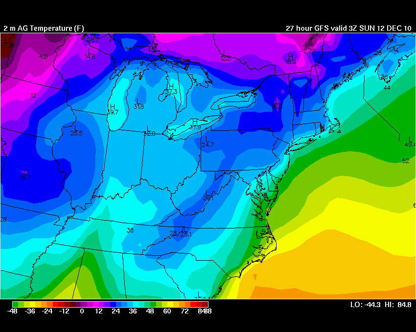
The above map is for Monday morning. Extremely cold air will filter into our region. These are temperatures we might see in the middle or end of January. Single digits to lower teens will be widespread over our area. Bitterly cold air - bitterly cold wind chill values (well below zero).

The above map shows the low temperatures for Tuesday morning. Bitterly cold air. Temperatures will be lower if we actually do receive a dusting or so of snow.

The above map shows the entire United States for Tuesday morning. An amazing cold outbreak (once again).
Another impact of this storm system will be the strong and gusty winds. Let's take a look at a few maps of what our wind speeds are expected to be - along with arrival times for those gusty winds.

The above map is for this evening (Saturday evening). You can see gusty winds are starting to develop to our west. These winds will increase through the night and into Sunday. The scale below the map is in knots.

The above map is for Sunday morning. Strong winds over much of our region - highest winds at this time will be over Missouri and Illinois. Spreading east/southeast.

The above map is for Sunday afternoon - strong and gusty winds over our entire region. Winds will be gusting in the 20-30 mph range. Gusts over 40 mph can't be ruled out in open areas and on area lakes. Low wind chill values will accompany these winds. Again - any snow that falls will likely blow around quite a bit in open areas. There are still questions on whether or not we will see any accumulation.

The above map is for Sunday evening - around 6 pm. Winds continue to be strong over our region. Bitterly cold wind chill values will occur with these winds.

The above map is for Sunday night - you can see that the winds will start to die down some during the overnight hours. Gusty winds will still occur - but not as strong as earlier in the day.
Computer models do not do very well with predicting snowfall in these type of situations. It will be difficult to say whether all of southern Illinois and western Kentucky will be able to squeeze out any accumulating snow from this system. I would not be surprised to see a dusting to up to an inch over our immediate local counties. I believe, however, that the best chance for accumulating snows will be to our east and northeast.
This will need to be monitored.
Here is what the GFS (one model of choice) is showing for snowfall totals for Saturday night into Tuesday. For our area the main concern would be on Sunday - a chance for a dusting of snow. Areas to the east will continue to have snow chances into Monday and Tuesday (eastern Kentucky).

HPC has issued some updates probability maps. This is for the probability of 1" or more of snow and 2" or more of snow. You can see that some of our counties are in at least a risk for snow.

The above map is the 1" or greater probability forecast. The map below is for 2" or greater of snowfall. Again these are probability maps.

A few more maps - the maps below are wind chill value maps for this system. Extremely cold wind chill values over the Ohio Valley.

The above map shows you the wind chill values for later tonight (around 9-11 pm)

The above map indicates extremely cold wind chill values for Sunday night. This map is for around the 6 pm to 11 pm time frame (Sunday night).
A variety of winter weather advisories may be necessary on Sunday into Tuesday across portions of Kentucky. Areas to our east will receive the best chance for accumulating snows. The main threat for any winter precipitation over western Kentucky would be late tonight and on Sunday. There are still questions on the exact track of the upper level low. This will be key to any snowfall accumulations. Stay tuned.
Transportation Cabinet Districts:
Some snow and blowing snow will certainly be a problem over the next 48-72 hour period - especially over the eastern and northern half of Kentucky.
Rainfall today (Saturday) will be moderate at times. This is likely going to wash some of the salt and chemicals off of the road. Rainfall totals in a six to eight hour period will likely in around 1/2-1" over the state - especially the western/central portion of the state.
Keep in mind that you shouldn't focus too much on the totals - whether 1" or 2" of snow falls - the high winds are going to cause problems with reduced visibility and blowing snow.
Least impact will be on districts 1, 2, and 3. This is where the least amount of snow is expected. However, any snow that does fall would blow around quite a bit. So - this could be an issue even if there is just a dusting or an inch or two of snow. Something to keep in mind.
Most impact will be on districts 4, 5, 6, 7, 8, 9, 10, 11, and 12.
Heavier snow possible over districts 8, 9, 10, 11, 12. Especially 11 and 12.
I am expecting a dusting up to one inch (isolated 2") of snow over districts 1, 2, and 3.
1"- 3" over district 4.
2-4" over districts 5, 6, 7, and parts of district 9. (topography favored snow areas will receive more - as they always do)
Higher accumulations will be likely over districts 8, 9, 10, 11, and 12.
Again the exact track of this upper level low is still in question. The track of the low will be key to snowfall amounts. The above amounts are my thinking as of 1 am Saturday morning.
Strong winds and rapidly falling temperatures are going to compound travel problems in areas that do receive snow. Blowing and drifting snow will be a concern on Sunday and Sunday night over portions of the State of Kentucky. See the latest advisories from the NWS concerning watches and/or warnings.
Temperatures will likely fall from the 40s into the 20s within a four to six hour period of time as the front pushes from the west towards the east. The front will arrive in western Kentucky after 5 pm and sweep eastward. See the above temperature maps for a rough idea on arrival time for the cold front and winds.
Emergency Management Districts:
Light accumulations (less than 3") possible over Western, Western Central and Western Bluegrass.
Light to moderate accumulations (1-4") are possible over Northern, South-central, Eastern Bluegrass, Northeastern, Southeastern, and Eastern Kentucky. Western Bluegrass is a toss-up on being between lighter amounts and a bit higher totals.
Highest totals would be in the southeast/eastern part of the State of Kentucky where 4 or more inches if expected to fall.
The next storm system will approach our region towards the end of next week. But - for now - let's deal with storm number 1.
- Meteorologist Beau Dodson
McCracken County Office of Emergency Management
Please visit Chris Bailey's weather blog if you live in central and eastern Kentucky http://www.kyweathercenter.com/
For the latest watches and warnings please visit your local National Weather Service Office http://www.weather.gov/organization.php
No comments:
Post a Comment