August 31, 2010 - Evening update
Here is the forecast track for Earl from Environmental Canada - the eventual track could be a bit left of this - but at least this gives you a good idea of what forecasters are expecting.
48 Hour Forecast Map - www.wright-weather.com image
August 31, 2010
As expected the tropics have come to life and come to life with a vengeance. We have hurricane Earl that is causing problems in the Caribbean. We also have newly formed tropical storm Fiona right behind Earl. A third area of disturbed weather just came off of Africa. Plenty to watch in the coming days.
You can receive the latest track forecasts by visiting the National Hurricane Center's web-site - here.
I expect that Hurricane Earl will give the southeast and east coast quite the scare. However, the hurricane should stay just off-shore (but it is a close call - so stay tuned if you have interests there). High seas and heavy rains - strong winds will brush the coastline and immediate inland areas. Hurricane force winds will be possible near the coast in North Carolina and Virginia - then northeast into Maine. Whether Earl actually comes ashore or not is still in question - but very close.
This is a dangerous hurricane and any shift in movement could have significant impact on sensible weather. Bottom line - those near the southeast and east coast of the United States should continue to closely monitor track forecasts in the coming days - I would not write Earl off and there will be impacts for the Carolina coastline areas into the northeast.
Tropics are going to be active through September.
For our region - the weather will be much more pleasant. A few showers and thunderstorms will be widely scattered over the region today. A better chance of showers and storms will move into our region later this week as a cold front approaches from the west. At this time it appears the best chance for rain will arrive on Thursday night.
Much of the area continues to find itself in drought conditions. This will continue into September. The official forecasts (see previous posts) is for above normal temperatures and below normal precipitation for the month of September.
I do have some concerns that September might end up bring a bit cooler weather (not that anyone would complain) than the official forecasts - I see several cold frontal passages in the coming weeks. However, for now we will stick with the official NOAA forecast and see what happens.
Over the next 5 days I would expect heavy rainfall over portions of Missouri and Illinois - north of our local region. Several inches of rain will be possible across portions of central and northeast Missouri into central and northern Illinois. Feast or famine - as I like to say.
Your 72 hour rainfall map (note the heavier rains to our north and west). As always, you can click the image for a larger view.
Below: 72 hour rainfall forecast - supplied by www.wright-weather.com
Meteorological fall begins on Wednesday. A signal that the seasons are changing. I have also noticed that the long range models are showing hints of deeper lows and stronger cold fronts. Another sign of fall.
There will be a few showers and thunderstorms scattered around our region today. Then again on Thursday night and Friday morning. Next chance of rain appears to be towards the middle of next week and then the following weeks - possible two more cold frontal passages.
You can view your seven day forecast, issued by the National Weather Service, by clicking here.
To view radar - click here.
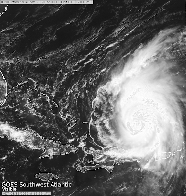
The forecast track for Hurricane Earl and a satellite image from WeatherTap.com - as always you can click the image for a larger view.
Below: Track forecast for Hurricane Earl.
Below: Satellite image of Hurricane Earl
OK - that is the weather for now. When weather becomes personal check back here and on Facebook for updates.
- Beau Dodson


No comments:
Post a Comment