January 1, 2011: Rain will come to an end - quiet few days ahead

January 1, 2011:

I am starting to post video briefings. You can find those by clicking the link below.
http://weatherobservatory.com/weather-video.htm

You can find more updates on my Facebook (under Beau Dodson) - Twitter, as well.  

If you would like to be added to the severe weather email list then please email me and request to be added - I usually send out an email during significant weather events.  Email me at beaudodson@usawx.com


Bottom line it for me Beau...

For southern Illinois and far western Kentucky...

The forecast for severe or extreme weather risk for today, tonight, and tomorrow: 0%

The forecast for freezing rain, sleet, or snow today, tonight, and tomorrow:  0%

Forecast:

New Years Day...Rain ending early then decreasing clouds. Highs in the mid 40s. West winds 5 to 10 mph.

Saturday Night...Mostly clear. Lows in the lower 20s. Northwest winds around 5 mph.

Sunday...Sunny. Highs around 40. West winds around 5 mph.

Sunday Night...Clear. Lows in the lower 20s. Southwest winds around 5 mph. 

Monday...Mostly sunny. Highs in the mid 40s. 

Monday Night...Partly cloudy. Lows around 30. 

Tuesday...Partly sunny. Highs in the upper 40s.

Your up to the minute National Weather Service seven day forecast for southern Illinois and western Kentucky can be viewed by clicking here.

Your regional and local radars - including precipitation type radar - click here.

Barometer readings can be viewed here  - Barometer Readings.

-----------------

You can view current conditions - weather radar and more information by clicking here
 
An active 24 hour period is coming to an end.  A significant tornado outbreak caused quite a bit of damage on New Year's Eve over portions of Oklahoma, Missouri, Illinois, Arkansas, and Mississippi.

Unfortunately, several people lost their lives in Missouri and Arkansas.

The Storm Prediction Center has a list of all of the severe weather reports on their web site.  You can view that list by clicking here.  You will need to adjust the date at the top of the page to view Friday's event.

Thankfully the weather during the upcoming week should be quieter. 

I am watching a system for the end of the week into next weekend. There is little agreement on the models as to how this event unfolds in our region - if at all.  Will monitor through the week and update accordingly.

Normal to perhaps slightly above normal temperatures are expected over the next 7 day period.  Kicking off our January. 

December was one of the colder December's on record. I am waiting on the final numbers from the Paducah, Kentucky National Weather Service Office.  The last few days were above normal in the temperature department. 

The below images show you the high temperature departures from normal for the week ahead (basically these maps shows you how much above or below normal temperatures are expected to be for the upcoming week - these are just daytime highs). 

You can see that we are expecting normal to perhaps slightly above normal temperatures for the upcoming week.  These images are from http://www.wright-weather.com/


- Meteorologist Beau Dodson
McCracken County Office of Emergency Management

Please visit Chris Bailey's weather blog if you live in central and eastern Kentucky http://www.kyweathercenter.com/

For the latest watches and warnings please visit your local National Weather Service Office http://www.weather.gov/organization.php

To view all watches and warnings in Kentucky - Click here
To view all watches and warnings in Illinois - Click here
Other States - Click Here

This site is non-profit and brought to you as a public service.

December 31, 2010: Severe thunderstorm and tornado threat today...

December 31, 2010:

8 PM Update

Mostly a rain event this evening.  Tornado watches have expired or been canceled.  Appears the main threat the rest of tonight will be moderate to heavy rain.  Can't rule out some isolated severe weather.  We remain in a slight risk according to the Storm Prediction Center.

Listen to local media and NOAA Weather Radio for updates.

Radar
http://weatherobservatory.com/weather-radar.htm

- Beau


December 31, 2010:

6 PM Update:

Thunderstorms are moving through our local area.  There have not been any reports of severe weather over the last couple of hours.

A tornado watch continues until 7 pm for many of our counties.

Severe weather can't be ruled out this evening.

Listen to local media and NOAA Weather Radios for the latest watches and warnings - or see links below.

Have a safe New Years Eve

- Beau


December 31, 2010

1:45 PM Radar - severe storms spreading into the western half of our region


Your regional and local radars - including precipitation type radar - click here.

Latest radar
http://radar.weather.gov/Conus/full.php

December 31, 2010
1 PM Update

Tornado watches have been issued for much of our region.  Several tornadoes have struck Missouri and Arkansas this morning with at least 5 people killed.

Severe thunderstorms will push into our region in the coming hours.

Listen to NOAA Weather Radio and local media for updates on this weather situation.

Your regional and local radars - including precipitation type radar - click here.
 
For the latest watches and warnings please visit your local National Weather Service Office http://www.weather.gov/organization.php

To view all watches and warnings in Kentucky - Click here
To view all watches and warnings in Illinois - Click here
Other States - Click Here

----------------------

December 31, 2010:
I am starting to post video briefings!  You can find those by clicking the link below
http://weatherobservatory.com/weather-video.htm  Note there will be new and old videos on the page. 

You can find more updates on my Facebook (under Beau Dodson) - Twitter, as well.  I also have been posting the videos on my Facebook updates.  Please check those out, as well.

If you would like to be added to my email list then please email me and request to be added - I usually send out an email when something significant is occurring or forecast to occur.  Email me at beaudodson@usawx.com


Bottom line it for me Beau...

For southern Illinois and far western Kentucky...

The forecast for severe or extreme weather risk for today, tonight, and tomorrow: Severe thunderstorms possible this afternoon and evening.  Isolated tornadoes can't be ruled out.

The forecast for freezing rain, sleet, or snow today, tonight, and tomorrow:  0%

Forecast:

Friday - a period or two of showers and thunderstorms.  Especially late in the day and evening.  High temperature in the middle 60s. A few storms may be severe with tornadoes possible.

Friday Night...Mostly cloudy. Rain showers and a chance of thunderstorms in the evening...Then a chance of rain showers after midnight. Lows around 41. South winds 10 to 15 mph in the evening shifting to the west at 10 mph after midnight. 

New Years Day...Partly sunny. Highs in the mid 40s. Northwest winds 5 to 10 mph.

Saturday Night...Clear. Lows around 23 degrees. Northwest winds around 5 mph.

Sunday...Mostly sunny. Highs around 40.

A fairly quiet week is ahead of us - after this storm system.  I will keep an eye on some potential for stormier weather after the first week of January.  Also keeping an eye on whether or not January will end up a bit more balanced than December.  Meaning more above normal temperature days vs below normal temperatures.   

Your up to the minute National Weather Service seven day forecast for southern Illinois and western Kentucky can be viewed by clicking here.

Your regional and local radars - including precipitation type radar - click here.

Barometer reading this morning is in the 30.00 - 30.30" range.  Last 24 hours of data - click here.

-----------------

You can view current conditions - weather radar and more information by clicking here
 system.  Locally heavier amounts are not out of the question for some of our counties. 

A frontal system will approach our region today and bring with it a chance for showers and thunderstorms to our region.  There will be a risk of severe thunderstorms today with isolated tornadoes.

The best chance of severe weather may be down in Arkansas and Tennessee.  Listen for later updates and possible watches/warnings throughout the day and into the evening hours.

Otherwise - fairly mild today and then turning cooler tonight and tomorrow.


The above graphic shows you the temperatures for this afternoon.  Then the image below shows you the cold air moving in behind the cold front later tonight and tomorrow morning.


You can see that a bit better with the image below - from www.wright-weather.com  Click for a larger view.  This is a map showing the temperatures for later this evening.  See the cold front on there?


Let's take a look at just hold cold and dry it has been during the past month.  We still need rain - drought conditions continue to be a problem in our region.


The above map shows you the departure from normal temperatures.  The blue and purple areas are temperatures that were WELL below normal for the month of December.  Just amazing.  Click map for a larger view.


The above map shows the entire nation - departure from normal temperatures.  The blue and purple areas are colder than normal the orange and red areas are above normal temperatures for the Month of December.  Click images for a larger view.


The above map shows the percent of normal precipitation.  As you can see on that map - we are below normal in the precipitation department.  Click for larger image.


The above map is zoomed in on our region.  You can see that we are below normal in precipitation.  The percent of normal precipitation is in the 25-50% range.   Meaning half the normal precipitation for the past month.  Click image for a larger view.

No strong signals for a snowstorm in the near term.  Will keep watching!

Happy New Years


- Meteorologist Beau Dodson
McCracken County Office of Emergency Management

Please visit Chris Bailey's weather blog if you live in central and eastern Kentucky http://www.kyweathercenter.com/

For the latest watches and warnings please visit your local National Weather Service Office http://www.weather.gov/organization.php

To view all watches and warnings in Kentucky - Click here
To view all watches and warnings in Illinois - Click here
Other States - Click Here

This site is non-profit and brought to you as a public service.

December 30, 2010: Holiday outlook - some rain and rumbles of thunder

December 30, 2010:
 
I am starting to post video briefings!  You can find those by clicking the link below
http://weatherobservatory.com/weather-video.htm

You can find more updates on my Facebook (under Beau Dodson) - Twitter, as well.  I also have been posting the videos on my Facebook updates.  Please check those out, as well.

If you would like to be added to my email list then please email me and request to be added - I usually send out an email when something significant is occurring or forecast to occur.  Email me at beaudodson@usawx.com


Bottom line it for me Beau...

For southern Illinois and far western Kentucky...

The forecast for severe or extreme weather risk for today, tonight, and tomorrow: Slight chance for strong storms on Friday afternoon and Friday evening.. 

The forecast for freezing rain, sleet, or snow today, tonight, and tomorrow:  0%

Forecast:

Tonight - Cloudy with a few scattered showers and thunderstorms around the area.  Mild.  Low temperatures in the 50s.  South winds at 5 mph.

Friday - a period or two of showers and thunderstorms.  Especially late in the day and evening.  High temperature in the middle 60s.

Friday Night...Mostly cloudy. Rain showers and a chance of thunderstorms in the evening...Then a chance of rain showers after midnight. Lows around 41. South winds 10 to 15 mph in the evening shifting to the west at 10 mph after midnight. 

New Years Day...Partly sunny. Highs in the mid 40s. Northwest winds 5 to 10 mph.

Saturday Night...Clear. Lows around 23 degrees. Northwest winds around 5 mph.

Sunday...Mostly sunny. Highs around 40.

Your up to the minute National Weather Service seven day forecast for southern Illinois and western Kentucky can be viewed by clicking here.

Your regional and local radars - including precipitation type radar - click here.

Barometer reading this morning is in the 30.00 - 30.30" range.  Last 24 hours of data - click here.

-----------------

You can view current conditions - weather radar and more information by clicking here
 system.  Locally heavier amounts are not out of the question for some of our counties. 


- Meteorologist Beau Dodson
McCracken County Office of Emergency Management

Please visit Chris Bailey's weather blog if you live in central and eastern Kentucky http://www.kyweathercenter.com/

For the latest watches and warnings please visit your local National Weather Service Office http://www.weather.gov/organization.php

To view all watches and warnings in Kentucky - Click here
To view all watches and warnings in Illinois - Click here
Other States - Click Here

This site is non-profit and brought to you as a public service.

Decmber 29, 2010 Some more rain heading our way

December 29, 2010


If you would like to be added to my email list then please email me and request to be added - I usually send out an email when something significant is occurring or forecast to occur.  Email me at beaudodson@usawx.com


Bottom line it for me Beau...

For southern Illinois and far western Kentucky...

The forecast for severe or extreme weather risk for today, tonight, and tomorrow: 0%. 

The forecast for freezing rain, sleet, or snow today, tonight, and tomorrow:  0%

Forecast:

Tonight...Rain showers likely. Lows around 40. Temperature steady or slowly rising after midnight. South winds 10 to 15 mph.morning... 

Thursday - Cloudy. A slight chance of showers in the morning... Then patchy drizzle in the afternoon. Highs in the lower 50s. Southeast winds 10 to 15 mph. 

Thursday Night...Mostly cloudy. A slight chance of showers in the evening...Then a chance of showers after midnight. Lows around 50. Temperature steady or slowly rising after midnight. South winds 10 to 15 mph. Chance of precipitation 30 percent.

Friday...Slight chance for a heavy shower or thunderstorm.  Isolated severe.  Showers and thunderstorms possible.  Highs in the mid 60s. South winds 10 to 15 mph. t.

Friday Night...Cloudy. Occasional rain showers and a chance of thunderstorms in the evening...Then a chance of light rain after midnight. Lows in the upper 30s. South winds 10 to 15 mph in the evening shifting to the southwest 5 to 10 mph after midnight. 

New Years Day...Partly sunny. Highs in the lower 40s.

Your up to the minute National Weather Service seven day forecast for southern Illinois and western Kentucky can be viewed by clicking here.

Your regional and local radars - including precipitation type radar - click here.

Barometer reading this morning is in the 30.00 - 30.30" range.  Last 24 hours of data - click here.

-----------------

You can view current conditions - weather radar and more information by clicking here
A frontal system will approach our area later tonight and introduce rain chances back into our area.


- Meteorologist Beau Dodson
McCracken County Office of Emergency Management

Please visit Chris Bailey's weather blog if you live in central and eastern Kentucky http://www.kyweathercenter.com/

For the latest watches and warnings please visit your local National Weather Service Office http://www.weather.gov/organization.php

To view all watches and warnings in Kentucky - Click here
To view all watches and warnings in Illinois - Click here
Other States - Click Here

This site is non-profit and brought to you as a public service.

December 28, 2010: Ahoy - rain is in the forecast! Much needed - I might add

December 28, 2010:

You can find more updates on my Facebook (under Beau Dodson) - Twitter, as well.  I also have been posting the videos on my Facebook updates.  Please check those out, as well.

If you would like to be added to my email list then please email me and request to be added - I usually send out an email when something significant is occurring or forecast to occur.  Email me at beaudodson@usawx.com


Bottom line it for me Beau...

For southern Illinois and far western Kentucky...

The forecast for severe or extreme weather risk for today, tonight, and tomorrow: 0%. 

The forecast for freezing rain, sleet, or snow today, tonight, and tomorrow:  Very small chance of mixed precip early in the morning.

Forecast:

Today - Mostly sunny after some morning fog and heavy frost.  Cold this morning.  High around 37 degrees.

Tonight - Increasing clouds.  Lows in the upper 20s.

Wednesday - Cloudy. A slight chance for a mix of rain and sleet in the morning.  A chance of rain in the afternoon. Highs around 40. South winds 5 to 10 mph.

Wednesday Night  A chance for rain in the evening then a slight chance of rain after midnight. Lows in the upper 30s then rising temperatures late. Southeast winds around 10 mph. 

Thursday...Cloudy. A slight chance of rain.  Mostly dry.  Highs around 50.

Your up to the minute National Weather Service seven day forecast for southern Illinois and western Kentucky can be viewed by clicking here.

Your regional and local radars - including precipitation type radar - click here.

Barometer reading this morning is in the 30.00 - 30.30" range.  Last 24 hours of data - click here.

-----------------

You can view current conditions - weather radar and more information by clicking here
A frontal system will approach our area later tonight and introduce rain chances back into our area.

Early tomorrow morning we can't rule out some sleet pellets - IF the rain moves in early enough.  Otherwise just a plain cold rain is expected on and off into the evening.

Scattered showers are possible into Friday before a stronger cold front approaches our local region on Friday afternoon and evening.  This will spread widespread showers and some thunderstorms back into the area.  Widespread severe weather is not expected.

Rainfall totals by Saturday morning could be in the 1/2-1" range over our area.  We need the rain as drought conditions continue to plague portions of our local area.

Here is the 5 day rainfall forecast from the HPC - let's hope we can squeeze 1/2-1" out of this system.  Locally heavier amounts are not out of the question for some of our counties. 


5 Day Rainfall Forecast From The HPC


- Meteorologist Beau Dodson
McCracken County Office of Emergency Management

Please visit Chris Bailey's weather blog if you live in central and eastern Kentucky http://www.kyweathercenter.com/

For the latest watches and warnings please visit your local National Weather Service Office http://www.weather.gov/organization.php

To view all watches and warnings in Kentucky - Click here
To view all watches and warnings in Illinois - Click here
Other States - Click Here

This site is non-profit and brought to you as a public service.

December 27, 2010: A calm Monday - wet later this week

December 27, 2010:

Coming soon - starting next week I will be integrating the hazardous weather outlooks onto the Weather Observatory web-site.  Also - Jason Darnall and I will be adding winter weather radar from GREarth. 

You can find more updates on my Facebook (under Beau Dodson) - Twitter, as well.

If you would like to be added to my email list then please email me and request to be added - I usually send out an email when something significant is occurring or forecast to occur.  Email me at beaudodson@usawx.com


Bottom line it for me Beau...

For southern Illinois and far western Kentucky...

The forecast for severe or extreme weather risk for today, tonight, and tomorrow: 0%. 

The forecast for freezing rain, sleet, or snow today, tonight, and tomorrow:  A stray flurry here and there.


Forecast:

Today - Mostly cloudy this morning.  Clouds should thin this afternoon.  Cold weather continues.  High temperature near 32 degrees.

Tonight - Clear and continued cold.  Low temperatures in the upper teens and lower 20s across the area.

Tuesday - Mostly sunny.  A little warmer.  High around 39 degrees.

Tuesday night - Increasing clouds.  A slight chance of freezing drizzle over our far southwest counties (will keep an eye on this).  Lows in the upper 20s.

Wednesday - A slight chance of a mixture of precipitation during the early morning hours.  Then a chance for showers during the afternoon.  Highs around 41 degrees.

We will need to keep an eye on late Tuesday night and Wednesday morning for some freezing drizzle or light precipitation - especially over our southern and southwestern counties.

Rain chances increase later on Wednesday into Thursday and again for Friday/Saturday.  Can't rule out some thunderstorms towards the end of the week with locally heavy rainfall.

Your up to the minute National Weather Service seven day forecast for southern Illinois and western Kentucky can be viewed by clicking here.

Your regional and local radars - including precipitation type radar - click here.

Barometer reading this morning is in the 30.20 - 30.50" range.  Last 24 hours of data - click here.

-----------------

You can view current conditions - weather radar and more information by clicking here


The above graphic was created by the Paducah, KY NWS Office.  This sums up the week.

- Meteorologist Beau Dodson
McCracken County Office of Emergency Management

Please visit Chris Bailey's weather blog if you live in central and eastern Kentucky http://www.kyweathercenter.com/

For the latest watches and warnings please visit your local National Weather Service Office http://www.weather.gov/organization.php

To view all watches and warnings in Kentucky - Click here
To view all watches and warnings in Illinois - Click here
Other States - Click Here

This site is non-profit and brought to you as a public service.

December 26, 2010: Chilly - a stray flurry - warm up at end of week.

December 26, 2010:

Coming soon - starting next week I will be integrating the hazardous weather outlooks onto the Weather Observatory web-site.  Also - Jason Darnall and I will be adding winter weather radar from GREarth. 

You can find more updates on my Facebook (under Beau Dodson) - Twitter, as well.

If you would like to be added to my email list then please email me and request to be added - I usually send out an email when something significant is occurring or forecast to occur.  Email me at beaudodson@usawx.com


Bottom line it for me Beau...

For southern Illinois and far western Kentucky...

The forecast for severe or extreme weather risk for today, tonight, and tomorrow: 0%. 

The forecast for freezing rain, sleet, or snow today, tonight, and tomorrow:  Some flurries and light snow showers over the region.


Forecast:

Today - A few flurries and scattered snow showers.  A period of light snow.  Small accumulations possible.  Still some slick spots.  Breezy.  Cold.  High temperature around 33 degrees.  North/Northwest winds at 10-15 mph.

Tonight - Partly cloudy.  Cold.  Low temperature around 17-20 degrees.

Monday - Mostly sunny.  Continued cold - below normal temperatures.  High around 32 degrees.

Monday night - Clear and cold.  Low temperature from 15-18 degrees.

Tuesday - Mostly sunny.  A little warmer.  High around 39 degrees.

We will need to keep an eye on late Tuesday night and Wednesday morning for some freezing drizzle or light precipitation - especially over our southern and southwestern counties.

Rain chances increase later on Wednesday into Thursday and again for Friday/Saturday.  Can't rule out some thunderstorms towards the end of the week with locally heavy rainfall.

Your up to the minute National Weather Service seven day forecast for southern Illinois and western Kentucky can be viewed by clicking here.

Your regional and local radars - including precipitation type radar - click here.

Barometer reading this morning is in the 30.00 - 30.20" range.  Last 24 hours of data - click here.

-----------------

Couple of graphics for you this morning

The Paducah, KY NWS has issued this graphic.  Pretty much sums up your week ahead.


The above graphic - from www.wright-weather.com shows what radar is expected to look like on Wednesday afternoon and evening.  You can see a band of showers over our region.  So - some chances for rain on Wednesday and Wednesday night.


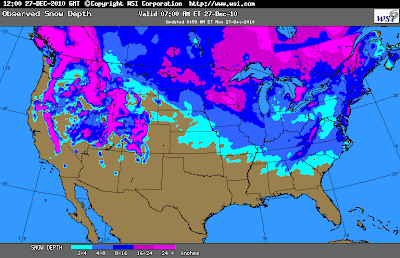
The graphic above shows you how much of the nation is covered in snow!  Quite impressive.


You can view current conditions - weather radar and more information by clicking here


- Meteorologist Beau Dodson
McCracken County Office of Emergency Management

Please visit Chris Bailey's weather blog if you live in central and eastern Kentucky http://www.kyweathercenter.com/

For the latest watches and warnings please visit your local National Weather Service Office http://www.weather.gov/organization.php

To view all watches and warnings in Kentucky - Click here
To view all watches and warnings in Illinois - Click here
Other States - Click Here

This site is non-profit and brought to you as a public service.

December 25, 2010: Flurries and light snow showers scattered around...

December 25, 2010:

Evening update -

No changes in forecast.

Light snow and flurries into tomorrow.  No significant accumulation is expected.

Our category 1 winter storm has moved east and should bring heavy snows to portions of the eastern United States.


Gusty winds tonight from the north/northwest at 10-20 mph with gusts to 25 mph.

No changes...

-  Beau


December 25, 2010

Your winter precipitation radar can be found by visiting my Weather Observatory web-site:
The URL is http://weatherobservatory.com/weather-radar.htm

You can find more updates on my Facebook (under Beau Dodson) - Twitter, as well.

If you would like to be added to my email list then please email me and request to be added - I usually send out an email when something significant is occurring or forecast to occur.  Email me at beaudodson@usawx.com


Bottom line it for me Beau...

For southern Illinois and far western Kentucky...

The forecast for severe weather risk for today, tonight, and tomorrow: 0%. 

The forecast for freezing rain, sleet, or snow today, tonight, and tomorrow: A period of snow this morning.  Light snow and flurries are expected to continue on and off today. Light accumulations not out of the question in the range of 1/2-1".


Forecast for southern Illinois and western Kentucky:

Today - Cloudy.  A period of snow.  Then light snow showers and flurries at times.  High temperatures around 34 degrees.  North winds at 5 to 10 mph.  Some light accumulation of snow can't be ruled out today from the areas of snow showers that form.  Accumulations of 1/2-1" possible.

Tonight - Cloudy.  A few light snow showers and flurries around the area.  Colder.  Low temperature near 23-25 degrees.  Northwest winds at 5-10 mph.

Sunday - Cloudy.  Some flurries or light snow.  Colder.  High in the upper 20s to lower 30s.  West/northwest winds at 15 mph.

Sunday night - Mostly cloudy and cold.  Low temperatures from 16-20 degrees.

Monday - Mostly sunny and cold.  High temperature near 32 degrees.

Your up to the minute National Weather Service seven day forecast for southern Illinois and western Kentucky can be viewed on the Weather Observatory web-site -  click here.

Your regional and local radars - including precipitation type radar - click here.

Barometer reading this morning is in the 30.00 - 30.30" range.  Last 24 hours of data - click here.

-----------------

Well - it was the single worst forecast of the year for the City of Paducah and McCracken County.  A few other areas, as well.  A thin band - about 10 to 15 miles wide - of heavier snow formed yesterday evening across extreme southern Illinois and parts of western Kentucky.  This band produced 2-4" of snow.  See radar images below.

My forecast was for a dusting over the southern portion of the area with 1/2-1" for the Metropolis/Paducah area and then 1-3" across parts of southeast MO into southern IL and into the Evansville area.

For the most part the forecast was great.  But for those areas where the forecast was a complete bust - I apologize.  It is just about impossible to predict a small band like that.  I was not happy with my forecast.  Wish I would have done better. 

There were a lot of wrecks in the areas hardest hit by the heavy snow.

Dexter, Kentucky reported 1" of snow.  Meanwhile, a few miles north of Dexter there were reports of 4" of snow.  At my place I didn't even record 1" of snow.  Actually between 0.60-0.80" as of 10 pm - meanwhile Metropolis had 2 to 2.5" of snow.

Needless to say this was a difficult forecast.  I have always said that winter storm forecasting is the single hardest forecast to produce in our region.  Tonight was just another example of that fact.

Again - I apologize for missing the forecast in that small band.

A period of snow this morning.  Then some light snow and flurries will continue on and off into Sunday.  There could be some minor accumulation in a few counties.  Sometimes these snow showers can form over an area and produce small pockets of accumulation.

Check radar for the latest look at where precipitation is or is not falling.

Jason Darnall sent me these radar grabs of the heavy snow bands (see above).  You can see that some areas picked up quite a bit more snow than other areas.  Some fairly large flakes were reported in the bright pink areas.  Click each image for a larger view.


I am watching a system for the middle of the week and another towards the end of the week.  Stay tuned for updates on these systems. 

I hope everyone has a VERY MERRY CHRISTMAS - stay safe and enjoy the holidays.

- Meteorologist Beau Dodson
McCracken County Office of Emergency Management

Please visit Chris Bailey's weather blog if you live in central and eastern Kentucky http://www.kyweathercenter.com/

For the latest watches and warnings please visit your local National Weather Service Office http://www.weather.gov/organization.php

To view all watches and warnings in Kentucky - Click here
To view all watches and warnings in Illinois - Click here
Other States - Click Here

This site is non-profit and brought to you as a public service.

December 24, 2010: Light snow likely later today into Saturday/Sunday.

December 24, 2010:

9 PM Update:

A heavier snow band formed over extreme southern Illinois and a small area of west Kentucky.  The area under the heavier band received 2-3" more than expected.  Horrible forecast - to say the least.  But - that happens in these situations from time to time. 

Some snowfall reports...

Less than 1" of snow here at my place in central Massac County.  Reports out of McCracken County of 3-4" of snow.  Dexter, KY has 1" of snow and 10 miles north of there are reports of 4" of snow. 

The single worst forecast I have made this year for the City of Paducah - I was thinking 1/2-1".  Obviously they got a lot more.  Not very happy about the end result for the 10-15 mile strip that ended up with heavier snow.  My apologies for a horrible forecast.

There have been a lot of wrecks in areas that received the heavier snow band.  Please use caution.

Light snow will continue overnight and tomorrow.  Some additional accumulation is possible. 

-Beau


December 24, 2010

I have posted a video on my Facebook - for those interested.  I will soon be integrating those videos into my web-site.

Your winter precipitation radar can be found by visiting my Weather Observatory web-site:
The URL is http://weatherobservatory.com/weather-radar.htm


Remember quite a bit of what you see on radar this morning is actually virga.  That is precipitation that is falling from the clouds but not reaching the ground (it is evaporating in the dry air).  It takes time for the atmosphere to saturate when we have dry air at the surface.  Once the air saturates this the snow will reach the ground.

There have been some reports this morning of flurries and light snow in the Carbondale area.  So - some of that is reaching the ground.

You can find more updates on my Facebook (under Beau Dodson) - Twitter, as well.

If you would like to be added to my email list then please email me and request to be added - I usually send out an email when something significant is occurring or forecast to occur.  Email me at beaudodson@usawx.com


Bottom line it for me Beau...

For southern Illinois and far western Kentucky...

The forecast for severe weather risk for today, tonight, and tomorrow: 0%. 

The forecast for freezing rain, sleet, or snow today, tonight, and tomorrow: Light snow and flurries will develop later today and this afternoon over far southern Illinois and western Kentucky.  This precipitation could start out as a mixture of rain, sleet, freezing rain, and snow.  Then change to all snow as colder air filters into the region.  A dusting to an inch for many of us.  Areas to the north should receive a bit more.


Forecast for southern Illinois and western Kentucky:

Today - Cloudy.  Flurries or light snow.  Precipitation could start out as a mixture of cold rain, sleet, freezing rain, and snow before changing to all snow.  High temperatures around 33-34 degrees.  Northeast winds at 7-10 mph.

Tonight - Cloudy.  Light snow likely.  Minor accumulation possible.  A dusting to 1" in most areas of far southern Illinois and western Kentucky.  Northeast winds at 5-10 mph.

Saturday - A chance for light snow or flurries.  Colder.  High in the upper 20s and lower 30s.  West/northwest winds at 10-15 mph.  Total snow accumulation of 1/2"-3" across our area.  More to the north/northwest/northeast and less to the south/southwest.

Saturday night - Flurries possible.  Colder.  Low near 23 degrees.  West/northwest winds at 15 mph.  

Sunday - Cloudy.  Some flurries or light snow.  Colder.  High in the upper 20s.  West/northwest winds at 15 mph.

Anyone with travel plans on Friday into Saturday should check road conditions and the latest forecasts - watches - warnings.

Your up to the minute National Weather Service seven day forecast for southern Illinois and western Kentucky can be viewed on the Weather Observatory web-site -  click here.

Your regional and local radars - including precipitation type radar - click here.

Barometer reading this morning is in the 29.80 - 30.10" range.  Last 24 hours of data - click here.

-----------------

Good morning everyone!

I hope everyone is having a nice holiday weekend.  It is a bit cold outside.  But - it is December!

No big changes in the forecast this morning.  This is a small winter weather event for far southern Illinois and western Kentucky.  Don't expect much in the way of accumulation.  Perhaps enough to give us a white Christmas.

Areas to our north - say from Farmington, Missouri over to Carbondale and then to Evansville should receive a bit more snow than areas south of that line.  Perhaps an inch or two with isolated higher amounts in those areas.

To the south of that line this will be more of a novelty event - I would not be surprised to see a dusting in some of our counties with perhaps an inch or two scattered throughout the rest of the counties.

Again - not a big event.  However, there will be some slick spots on area roadways.  The NWS has issued some winter weather advisories to cover the possible impacts of this winter storm.

Here is the HPC probability of map of 1" or more of snowfall over the next 24 hours.


December will go down in the record books as one of the colder Decembers on record.  Quite amazing.

Big storm still possible around December 30th through January 2nd.  

Have a GREAT and SAFE holiday season!

- Meteorologist Beau Dodson
McCracken County Office of Emergency Management

Please visit Chris Bailey's weather blog if you live in central and eastern Kentucky http://www.kyweathercenter.com/

For the latest watches and warnings please visit your local National Weather Service Office http://www.weather.gov/organization.php

To view all watches and warnings in Kentucky - Click here
To view all watches and warnings in Illinois - Click here
Other States - Click Here

This site is non-profit and brought to you as a public service.

December 23, 2010: Light snow for the holiday - cold cold cold afterwards.

December 23, 2010:

Afternoon update -

New numbers show even less snow.   Definitely not looking like a big event.  Will stick with the forecast for 1/2"-1" over the central and southern portion of our region and 1-3" over the northern part of the region.

Northern part of area would basically be from near Farmington, MO to Evansville, Indiana.

For preparation purposes it would be best to plan of 1-3".  If it is a bit less than that then don't be disappointed.  If it is a little more for some of our northern counties then you will have been prepared.
 

Winter weather advisories will likely be issued for portions or all of our region over the coming 12 hours.  Mainly for tomorrow afternoon into tomorrow night and Saturday morning.

A wintry mix will be possible next Wednesday and Thursday.  Long way off and our focus is on event number 1 - first.


-  Beau


December 23, 2010:


Let me first say this - for those who have to travel (in any direction).


Snow is expected to break out over the Missouri Valley later tonight and tomorrow morning.  Snow will move into our region during late morning and afternoon hours on Friday.  Then across the rest of our area on Friday evening and Friday night.

DO NOT be surprised if western Kentucky and far southern Illinois do not see ANY flakes until very late afternoon or even into the evening hours.

The snow will spread east/southeast through the evening hours and cover the rest of the State of Kentucky by Friday evening and Friday night.

The above graphic is from the NWS Office out of Nashville, Tennessee.


-----------------------------------------------------------------------

I will update through the day - if there are changes.  Didn't feel a need to update yesterday because I don't see any changes (for our region).

All of the trends are towards less snow vs more.  I will hold with my original forecast for our region.  1/2" to 3".  More as you go north and northwest and less as you move southward.

There are still a lot of questions on this storm.  Changes could still be made to the forecast.  

You can find more updates on my Facebook (under Beau Dodson) - Twitter, as well.

If you would like to be added to my email list then please email me and request to be added - I usually send out an email when something significant is occurring or forecast to occur.  Email me at beaudodson@usawx.com


Bottom line it for me Beau...

For southern Illinois and far western Kentucky...

The forecast for severe weather risk for today, tonight, and tomorrow: 0%. 

The forecast for freezing rain, sleet, or snow today, tonight, and tomorrow: Snow likely on Friday afternoon late over our west and northwest areas and into the rest of the area Friday evening and night. 


Forecast for southern Illinois and western Kentucky:

Today - Partly sunny with high temperatures in the upper 30s.  North winds at 10-15 mph with gusts to 20 mph.

Tonight - Cloudy.  Cool.  Low temperature around 26-30 degrees.  Northeast wind 5-10 mph.

Friday - A good chance of snow and sleet during the late afternoon hours. High in the middle 30s with falling temperatures late in the day.  Northeast winds at 5-10 mph.  Gusts to 15 mph.

Friday night - A good chance for light snow.  Colder.  Windy.  Lows in the middle 20s.  Light accumulation of snow possible.

Saturday - A chance for light snow or flurries.  Colder.  High in the upper 20s and lower 30s.  West/northwest winds at 10-15 mph.  Total snow accumulation of 1/2"-3" across our area.  More to the northwest and less to the south/southwest.

Saturday night - Flurries.  Colder.  Low near 23 degrees.  West/northwest winds at 15 mph.  

Sunday - Cloudy.  Some flurries or light snow.  Colder.  High in the upper 20s.  West/northwest winds at 15 mph.

Anyone with travel plans on Friday into Saturday should check road conditions and the latest forecasts - watches - warnings.

Your up to the minute National Weather Service seven day forecast for southern Illinois and western Kentucky can be viewed on the Weather Observatory web-site -  click here.

Your regional and local radars - including precipitation type radar - click here.

Barometer reading this morning is in the 30.20 - 30.50" range.  Last 24 hours of data - click here.

-----------------

You can view current conditions - weather radar and more information by clicking here

Two main areas of precipitation are expected to develop on Friday.  One will be to our north and northwest and the other will be to our south and southwest.  Two pieces of energy.  The system to our north and northwest will attempt to merge with the southern system.

All of the above means a chance for light snow over all of our area.  Earlier in the week we thought the light snow might arrive on Thursday night and then it was pushed off until Friday morning.  It now appears that the bulk of the snow will hold off until late on Friday and Friday night.  This could be good news for those who have travel plans on Thursday or Friday morning.

At this time, I am expecting 1/2" to 3" of snow over our region.  It would not take much of a change in this storm system to bring less than those amounts - and we always end up with a bit of banding in these type of systems.  These bands produce slightly heavier snow.  We noticed that during the last event.

I have to add that there is some model data that continues to show our region receiving nothing more than a few flurries.  However, this is being discounted based out it being an outlier.  I thought I would continue to mention that fact.  It seems like these snow systems are always difficult to forecast in our region.

Here are a couple of graphics for you this morning

The first graphic is the NAM forecasted snowfall amounts and the second map is for the GFS.  Again - this is just what the models are showing.  It gives you a general idea.  The EC model shows us receiving flurries.


Some local NWS graphics


Expect very cold temperatures as we move into early next week.  I am also watching a potential storm system for the end of the month.

Expect our region to see lows in the single digits and teens next week.  Bitterly cold.

December will go down in the record books as one of the colder Decembers on record.  Quite amazing.

Big storm still possible around December 30th through January 2nd.  

Have a GREAT and SAFE holiday season!

- Meteorologist Beau Dodson
McCracken County Office of Emergency Management

Please visit Chris Bailey's weather blog if you live in central and eastern Kentucky http://www.kyweathercenter.com/

For the latest watches and warnings please visit your local National Weather Service Office http://www.weather.gov/organization.php

To view all watches and warnings in Kentucky - Click here
To view all watches and warnings in Illinois - Click here
Other States - Click Here

This site is non-profit and brought to you as a public service.

December 22, 2010: Happy Holidays! Watching our snow potential...First call

December 22, 2010:

Next update will be later this afternoon or evening.  Updates through the week.

As always there is a high amount of uncertainty as to how this storm unfolds.  A slight shift in track would have significant impacts on the final forecast.  

No video today - going to cover everything in the blog and email update.

You can find more updates on my Facebook (under Beau Dodson) - Twitter, as well.

If you would like to be added to my email list then please email me and request to be added - I usually send out an email when something significant is occurring or forecast to occur.  Email me at beaudodson@usawx.com


Bottom line it for me Beau...

For southern Illinois and far western Kentucky...

The forecast for severe or extreme weather risk for today, tonight, and tomorrow: 0%. 

The forecast for freezing rain, sleet, or snow today, tonight, and tomorrow: 0%.


Forecast for southern Illinois and western Kentucky:

Today - Partly sunny with high temperatures in the upper 30s.  North winds at 10-15 mph with gusts to 20 mph.

Tonight - Cloudy.  Cool.  Low temperature around 24-26 degrees.  Northeast wind 5-10 mph.

Thursday - Partly sunny.  Cool.  High temperature near 38 degrees.  East winds around 5 mph.

Thursday night - Cloudy and cold.  Low around 26-28.  East winds at 5 mph.

Friday - A good chance of snow and sleet during the afternoon (perhaps late afternoon).  Some light accumulation is possible.  High in the middle 30s with falling temperatures late in the day.  Northeast winds at 5-10 mph.  Gusts to 15 mph.

Friday night - A good chance for light snow.  Colder.  Windy.  Lows in the middle 20s.

Saturday - A chance for light snow or flurries.  Colder.  High in the upper 20s and lower 30s.  West/northwest winds at 10-15 mph.  Total snow accumulation of 1/2"-3" across our area.

Anyone with travel plans on Friday into Saturday should check road conditions and the latest forecasts - watches - warnings.

Your up to the minute National Weather Service seven day forecast for southern Illinois and western Kentucky can be viewed on the Weather Observatory web-site -  click here.

Your regional and local radars - including precipitation type radar - click here.

Barometer reading this morning is in the 30.00 - 30.30" range.  Last 24 hours of data - click here.

-----------------

You can view current conditions - weather radar and more information by clicking here

Here are two maps from the HPC this morning - the first one shows you the probability of 2" or more of snow-  This would be for Friday afternoon into Saturday.  The second map shows where light freezing rain could occur during the same time frame.


The above image is the NAM snowfall forecast - again just a computer model that I use for guidance.

Some changes this morning as we have a better idea of how this storm system is going to unfold.  All of the data has shifted southward over the last 24 hours for the track of the winter storm.  This is a huge score for the European model as it was the first to catch on to the idea that the main storm may track as far south as the Gulf of Mexico - I was quite skeptical of this solution.  However, since that time other data has moved towards the same solution.

With that in mind and after looking at everything else - this is how I see this unfolding (and the event is still several days away - so I will need to update and tweak the final forecast, of course).

Two main areas of precipitation are expected to develop on Friday.  One will be to our north and northwest and the other will be to our south and southwest.  Two pieces of energy.  The system to our north and northwest will attempt to merge with the southern system.

All of the above means a chance for light snow over all of our area.  Earlier in the week we thought the snow might arrive on Thursday night and then it was pushed off until Friday morning.  It now appears that the bulk of the snow will hold off until late on Friday and Friday night.  This could be good news for those who have travel plans on Thursday or Friday morning.

At this time, I am expecting 1/2" to 3" of snow over our region.  It would not take much of a change in this storm system to bring less than those amounts.  That is my first call on this system.

As all of you know (from living in this region) one can never count their snowflakes before they hatch.  With that in mind - I will update the forecast over the coming days.  At this point nothing would surprise me with this storm.  I have seen similar storms produce very little in the way of precipitation.

Of course if the storm were to move further north then we would need to adjust our numbers higher.  Still a lot of uncertainty surrounding this system.

The actual storm won't be sampled by the models until today.  That means that the model runs should be in better agreement on how this entire storm unfolds.

Expect very cold temperatures as we move into early next week.  I am also watching a potential storm system for the end of the month.

Expect our region to see lows in the single digits and teens next week.  Bitterly cold.

December will go down in the record books as one of the colder Decembers on record.  Quite amazing.  Now the big question is how does January and February turn out.

Stay tuned :)


Have a GREAT and SAFE holiday season!

- Meteorologist Beau Dodson
McCracken County Office of Emergency Management

Please visit Chris Bailey's weather blog if you live in central and eastern Kentucky http://www.kyweathercenter.com/

For the latest watches and warnings please visit your local National Weather Service Office http://www.weather.gov/organization.php

To view all watches and warnings in Kentucky - Click here
To view all watches and warnings in Illinois - Click here
Other States - Click Here

This site is non-profit and brought to you as a public service.

December 21, 2010: Watching the Christmas Eve and Christmas Day Storm...

December 21, 2010:

No more updates tonight - lot of new data is coming in at this hour.  However, I am going to get up early tomorrow morning to do a lengthy blog update.  No video tomorrow - might do something tomorrow night.

Going to focus on updating the email and blog - tomorrow morning.  Most likely will update around 7-8 am.

- Beau


December 21, 2010:

1 PM Update

Couple of maps - one is the GFS snowfall forecast and the second map is the NAM model.  I can tell you that one of our better models is showing only a dusting for western Kentucky and perhaps a few inches to our east.  There is a higher than normal amount of uncertainty with this developing storm.

I will maintain my current forecast for the low to track through Arkansas and into Mississippi/Alabama.  I will be surprised if it tracks all the way into the Gulf of Mexico - as one set of data is showing.

Next update will be late this afternoon or evening.

Here are what two models are showing:


December 21, 2010:

Next update will be around 830 AM and again around 3 PM (brief updates)

I have put together a detailed video concerning this upcoming storm -  I have updated the video-cast this morning.

REMEMBER - in order for the forecast thoughts on the video to pan out - we absolutely have to have the storm track correct or close to correct.  If this storm tracks MUCH further south than expected or even much further north then the forecast would change dramatically.

The video is made with some basic forecast assumptions already being made (which in winter that is asking a lot).  We all know how tricky these winter weather precipitation events can be.

You can view the video by clicking here.

You can find more updates on my Facebook (under Beau Dodson) - Twitter, as well.

If you would like to be added to my email list then please email me and request to be added - I usually send out an email when something significant is occurring or forecast to occur.  Email me at beaudodson@usawx.com


Bottom line it for me Beau...

For southern Illinois and far western Kentucky...

The forecast for severe or extreme weather risk for today, tonight, and tomorrow: 0%. 

The forecast for freezing rain, sleet, or snow today, tonight, and tomorrow:  Some light snow and flurries across the northern half of our area and northeast part of our region.


Forecast for southern Illinois and western Kentucky:

Today - A slight chance for light rain mainly before noon.  Patchy drizzle otherwise.  High temperatures near 50 degrees.

Tonight - Cloudy.  Cool.  Low temperature around 30 degrees.

Wednesday - Partly sunny.  Cool.  High temperature near 38 degrees.

Wednesday Night -Partly cloudy and cold.  Increasing clouds.  Low around 24 degrees.

Thursday - Increasing clouds.  Cold.  High temperature near 38 degrees.

Thursday night - Cloudy and cold.  Low around 28.

Friday - A good chance of snow and sleet.  Some accumulation is possible.  High in the lower 30s.

Friday night - A good chance for light snow.  Colder.  Windy.  Lows in the 20s.

Saturday - A chance for light snow or flurries.  Colder.  High in the 20s.  West/northwest winds at 10-15 mph.

I am watching apotent storm for Thursday night into Christmas Day.  This storm may spread a mixed bag of precipitation into our region on Friday morning.  Timing and exact track of this system is still uncertain.

Anyone with travel plans on Thursday into Saturday should check road conditions and the latest forecasts - watches - warnings.

Your up to the minute National Weather Service seven day forecast for southern Illinois and western Kentucky can be viewed on the Weather Observatory web-site -  click here.

Your regional and local radars - including precipitation type radar - click here.

Barometer reading this morning is in the 29.85 - 30.10" range.  Last 24 hours of data - click here.

-----------------

You can view current conditions - weather radar and more information by clicking here

One NWS graphics for you this morning.  This graphic is brought to you by the NWS Office in Louisville, Kentucky.  Exact timing of this system is still in question.  The latest data suggests that much of the precipitation will hold off until Friday morning over western Kentucky and then spread east during the day.  Click graphic to enlarge.


An area of precipitation is forecast to develop over our region on Thursday night and Friday morning.  There are a lot of questions this morning concerning what type of precipitation our local region will experience.  Stay tuned for updates.

As colder air moves in behind the area of low pressure whatever precipitation is left over is forecast to change back to light snow or flurries on Friday afternoon and Friday night.

The exact track of this storm will determine exactly what type of precipitation we can expect over southern Illinois and western Kentucky.  This storm has the potential to cause quite a few travel problems over portions of the central United States into the Ohio Valley and Great Lakes - possibly even as far south as the Tennessee Valley (depending on track).

Some travel problems are also expected over our region and the State of Kentucky.


A few graphics for you:  These graphics are brought to you by www.wright-weather.com - this is the website that I use for much of my weather data.


This is what the radar is forecast to look like at 7 am on Friday.  The blue area is snow and the green area is rain.


The above map shows the expected temperatures at 1 am on Monday morning.  As you can see - bitterly cold air is expected to once again invade our region (par for the course).


The above map shows the expected temperature at 1 am on Tuesday morning - these are not even the low temperatures.  As you can see - more cold.


The above map shows you the temperatures expected at 1 am on Wednesday morning.  Cold.  Bitterly cold.  If snow does cover much of the Ohio Valley then some areas can expect single digit or below zero readings.

Stay tuned for updates - especially if you have travel plans.


One last map - above.  This is one model - the EC - which is normally a great model to use for guidance.  However, it isn't always correct.   This shows the area of low pressure so far to the south that our region would only experience flurries or light snow.

Most of the data has been trending south with this system - the NAM and GFS, as well.  Just how far south appears to be the main question at this time.  As far south as the EC?  Or a blend of the GFS and EC?  Either way it would mean mainly snow for our region.

Obviously there are still questions on how this storm unfolds and the eventual track.

I will update through the day and into the coming days!

Have a GREAT and SAFE holiday season!

- Meteorologist Beau Dodson
McCracken County Office of Emergency Management

Please visit Chris Bailey's weather blog if you live in central and eastern Kentucky http://www.kyweathercenter.com/

For the latest watches and warnings please visit your local National Weather Service Office http://www.weather.gov/organization.php

To view all watches and warnings in Kentucky - Click here
To view all watches and warnings in Illinois - Click here
Other States - Click Here

This site is non-profit and brought to you as a public service.