It has been a long time since I made it changes to the weather blog. I am going to make a few changes. Hopefully you will like the changes.
I am going to travel more in 2013 - enjoy life a bit - immerse myself in learning photography (I need to learn how to use my camera). I am going to spend part of the winter photographing snowstorms in New England.
The work I do in the meteorological community is voluntary. I volunteer my time to emergency management, state, and other agencies. Forecasting weather is a task that I enjoy and it allows me to give back to the community as a whole. Many of you that read this blog also volunteer your time - emergency management, fire officials, weather spotters, and enthusiasts. Thank you for your support in keeping our region safe, as well.
What changes will I make in the blog?
I plan on updating the blog more often, but with short term updates. That means talking about today and tomorrow vs longer range. I will touch on the longer range at the bottom of the blog. The focus will be on what is happening now - immediate concerns/threats.
For most, there will not be any noticeable changes in the blog. I may move around some of the layout and I may combine some other areas. You will still find the threats area, severe weather outlooks, rainfall forecasts, and other information.
We recently updating our servers to better serve you during times of inclement weather conditions. IVS (out of Paducah, Kentucky) purchased a faster and more reliable server for the radars that you see on the main web-site. IVS, among others - Jason Darnall, have been instrumental in keeping the web-site up and running during period of severe weather.
Where I can find the most recent updates outside of the blog?
I typically update the Beau Dodson Weather Facebook page several times a day. I encourage you to visit that page, as well.
The main web-site can be viewed here - Weather Observatory
Our region has experienced an amazing number of extreme weather events over the last decade. More than I have ever witnessed and many of you, as well. So, with that in mind, I continue to encourage you to have a NOAA All Hazards Weather Radio to keep you and your family informed during inclement weather conditions. There are also many Apps available for your cell phones. If you have any questions about what Apps I use then feel free to email me at beaudodson @ usawx.com (get rid of the spaces before and after the @ symbol)
- Beau
For more frequent updates visit my weather Facebook page - click here and hit like at the top of the page.

This blog is best viewed with Mozilla Firefox. There could be issues with spacing on Internet Explorer

.
Here are my current personal forecast thoughts for far southern Illinois and western Kentucky...
Monday: Partly sunny and pleasant. Nice day for fall. A few clouds. Chance for a couple of showers or storms over our far northwest counties (MO/IL).
Highs: in the middle to upper 50s
Wind: South winds 10-15 mph
Precipitation probability - 10% | Rainfall totals: 0"
Confidence in this forecast is high
Forecast for your local town/city - Click Here
Wind: South winds at 10-15 mph
Precipitation probability - 10% | Rainfall totals: 0"
Confidence in this forecast is very high
Wind: Southerly winds at 10-20 mph
Precipitation probability - 20% for far southern IL and west KY and then 40-60% for northern and western areas | Rainfall totals: 0.25" in a few spots
Confidence in this forecast is high
Highs: in the middle to upper 50s
Wind: South winds 10-15 mph
Precipitation probability - 10% | Rainfall totals: 0"
Confidence in this forecast is high
Forecast for your local town/city - Click Here
Monday night: Some clouds - pleasant for fall.
Lows: in the upper 50s Wind: South winds at 10-15 mph
Precipitation probability - 10% | Rainfall totals: 0"
Confidence in this forecast is very high
.
Tuesday: A few clouds - mild for October. Pleasant day. A chance for a couple of showers and thunderstorms over parts of southeast Missouri and southern Illinois.
Highs: in the upper 70s Wind: Southerly winds at 10-20 mph
Precipitation probability - 20% for far southern IL and west KY and then 40-60% for northern and western areas | Rainfall totals: 0.25" in a few spots
Confidence in this forecast is high
Tuesday night: A few clouds - pleasant for October.
Lows: in the 53-56 degree range
Wind: south winds at 5-10 mph
Precipitation probability - 10% | Rainfall totals: 0"
Confidence in this forecast is high
Forecast for your local town/city - Click Here

This
forecast
analysis covers far southern
Illinois, southeast
Missouri,
southwest Indiana,
western Kentucky, and
northwest
Tennessee
HEADLINES: A warm front is passing through the region - this means that we will see warming temperatures on Monday with southerly breezes. Not bad for October - highs will be in the 70s.
There will be at least a chance for a few thunderstorms along the warm front on Monday into Tuesday - this would mainly be over portions of southeast Missouri into northwest parts of southern Illinois - draw a line from say Mt Vernon, Illinois back towards Perryville, Missouri.
Fall colors will continue to be on display during the upcoming week. Winds over the last week have knocked some leaves off the trees - however, a spot check around the area shows plenty of color remains.
The next significant weather system to impact our region will be towards the latter half of the week. A cold front is expected to move through the region on Friday or Saturday. This will bring at least a few showers and thunderstorms. Right now the severe weather threat appears minimal.
You can see the cold front here on this map from www.wright-weather.com. This is the GFS model (one model that meteorologists use to forecast the weather).
The purple area represents rain/showers/storms. The darker colors would be heavier rainfall. You can see the front line up across the central part of the nation. Deep area of low pressure up in Canada and a tropical feature off the coast of Florida.
Click images for a better view
Thursday night map:
The lines you see are isobars around the areas of low and high pressure. Typically when you see the lines tightly wound together then you can expect windy conditions. Again, the colored areas are precipitation - pink/purple/blue/other.

The image below is for Friday morning - you can see the front has not moved too much

Then we move ahead to Friday night and Saturday morning - the whole mess starts to shift eastward. A new low has formed over the Oklahoma/Kansas area and moved into the Ohio Valley.
Note there is a tropical feature off the southeast coast of the United States. That will need to be monitored for areas to our east. It is possible that the system moving over the Ohio Valley could combine with the east coast system - something to monitor in the coming days.

Bottom line is that there should be a chance for precipitation on Friday into Saturday - timing will need to be adjusted as we move into the workweek. Might be some rain showers for Friday Night Football in our area. If the east coast storm does develop then colder air will filter into our region by the end of the weekend into the beginning of next week. Still some uncertainties on how that plays out. Stay tuned because it may mean our first hard freeze by next week.
Temperatures this week will be above normal for the most part.
Check out the high temperature forecasts for Monday and Tuesday - above normal! This is behind the warm front - warm air moving back into our region.

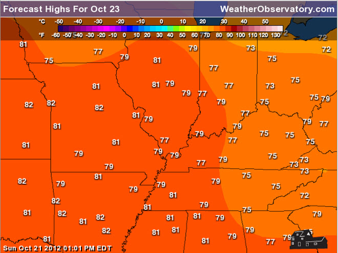 Normal high temperatures for this time of the year - see map below
 Normal lows for this time of the year

Wind: south winds at 5-10 mph
Precipitation probability - 10% | Rainfall totals: 0"
Confidence in this forecast is high
Forecast for your local town/city - Click Here
HEADLINES: A warm front is passing through the region - this means that we will see warming temperatures on Monday with southerly breezes. Not bad for October - highs will be in the 70s.
There will be at least a chance for a few thunderstorms along the warm front on Monday into Tuesday - this would mainly be over portions of southeast Missouri into northwest parts of southern Illinois - draw a line from say Mt Vernon, Illinois back towards Perryville, Missouri.
Fall colors will continue to be on display during the upcoming week. Winds over the last week have knocked some leaves off the trees - however, a spot check around the area shows plenty of color remains.
The next significant weather system to impact our region will be towards the latter half of the week. A cold front is expected to move through the region on Friday or Saturday. This will bring at least a few showers and thunderstorms. Right now the severe weather threat appears minimal.
You can see the cold front here on this map from www.wright-weather.com. This is the GFS model (one model that meteorologists use to forecast the weather).
The purple area represents rain/showers/storms. The darker colors would be heavier rainfall. You can see the front line up across the central part of the nation. Deep area of low pressure up in Canada and a tropical feature off the coast of Florida.
Click images for a better view
Thursday night map:
The lines you see are isobars around the areas of low and high pressure. Typically when you see the lines tightly wound together then you can expect windy conditions. Again, the colored areas are precipitation - pink/purple/blue/other.

The image below is for Friday morning - you can see the front has not moved too much

Then we move ahead to Friday night and Saturday morning - the whole mess starts to shift eastward. A new low has formed over the Oklahoma/Kansas area and moved into the Ohio Valley.
Note there is a tropical feature off the southeast coast of the United States. That will need to be monitored for areas to our east. It is possible that the system moving over the Ohio Valley could combine with the east coast system - something to monitor in the coming days.

Bottom line is that there should be a chance for precipitation on Friday into Saturday - timing will need to be adjusted as we move into the workweek. Might be some rain showers for Friday Night Football in our area. If the east coast storm does develop then colder air will filter into our region by the end of the weekend into the beginning of next week. Still some uncertainties on how that plays out. Stay tuned because it may mean our first hard freeze by next week.
Temperatures this week will be above normal for the most part.
Check out the high temperature forecasts for Monday and Tuesday - above normal! This is behind the warm front - warm air moving back into our region.

No major concerns at this time.

No.

No wild cards in this forecast package
.

.
Forecast for your local town/city - Click Here
We have a TON of new weather maps on the Weather Observatory web-site - these include temperatures, wind speed, dew points, heat index, barometric pressure, predicted rainfall, climate forecast, medium and long range maps, forecasts and more! Click here
Don't forget to sign up for the severe weather "heads up" email list - I usually email everyone before a big event - severe weather - tornado outbreaks - winter storms - ice storms. Click here to join
.
---

The forecast for severe or extreme weather
.
The McCracken County Office of Emergency Management reminds you that owning a NOAA All Hazards Weather Radio is the best way to receive notifications of severe weather watches and warnings.
.
Remember that the National Weather Service defines a severe thunderstorm as one that produces 58 mph winds or higher, hail 1" in size or larger, and/or a tornado.
Monday: Severe weather is not anticipated. No snow or ice.
Is there a chance for thunderstorms BELOW severe limits Yes - a few thunderstorms possible over northern and northwestern parts of the area.
Tuesday: Severe weather is not anticipated. No snow or ice.
Is there a chance for thunderstorms BELOW severe limits? Yes - can't rule out a few storms over parts of southern Illinois and southeast Missouri - further north and west the better the chance.
Wednesday : Severe weather is not anticipated. No snow or ice.
Is there a chance for thunderstorms BELOW severe limits? No
.
For the most up to date severe weather outlooks - click here.
For the most up to date severe weather outlooks - click here.
or
Visit the Storm Prediction Center's web-site - click here
To view storm reports from today and yesterday - click here
.
 .
.
Will the Storm Prediction Center issue a tornado or severe thunderstorm watch for southeast Missouri, southern Illinois, or western Kentucky?
To view storm reports from today and yesterday - click here
.
Will the Storm Prediction Center issue a tornado or severe thunderstorm watch for southeast Missouri, southern Illinois, or western Kentucky?
Monday - No
Tuesday - No
To view the official Storm Prediction Center's web-site - click here Alternative link - click here
Tuesday - No
To view the official Storm Prediction Center's web-site - click here Alternative link - click here

.
To view all watches and warnings in IL - Click Here
To view all watches and warnings in KY - Click Here
To view all watches and warnings in MO - Click Here
To view all watches and warnings in TN - Click Here
All other states- Click Here
To view all watches and warnings in IL - Click Here
To view all watches and warnings in KY - Click Here
To view all watches and warnings in MO - Click Here
To view all watches and warnings in TN - Click Here
All other states- Click Here
.
The
links above are interactive and
you can move
around the United States by
simply clicking on the
national map - or
from the pull down menu
where it says regions and
US States.
.
To view the interactive warning map - click here.
.
 .
.
You can listen to local emergency services, SKYWARN storm spotters, and more by visiting our scanner feed page - click here
.
 .
.
The Weather Observatory is a strong partner with the National Weather Service - click here to visit your local NWS web-site. For the most up to date warnings/advisories hit refresh on their page.
 .
.
We have a number of new radars available on our Weather Observatory web-site !
---
We now offer St Louis, Mt Vernon, Evansville, Poplar Bluff, Cape Girardeau, Marion, Paducah, Hopkinsville, Memphis, Nashville, and Dyersburg Interactive City Radars. I have added all of eastern Kentucky, as well.
We also have the two regional radars and now offer you three GR Earth radars.
Click here for our radar page - WEATHER RADARS ---
---
We also have a new interactive radar - you can view that radar by clicking here.
.
To view the interactive warning map - click here.
.
You can listen to local emergency services, SKYWARN storm spotters, and more by visiting our scanner feed page - click here
.
The Weather Observatory is a strong partner with the National Weather Service - click here to visit your local NWS web-site. For the most up to date warnings/advisories hit refresh on their page.
. We have a number of new radars available on our Weather Observatory web-site !
---
We now offer St Louis, Mt Vernon, Evansville, Poplar Bluff, Cape Girardeau, Marion, Paducah, Hopkinsville, Memphis, Nashville, and Dyersburg Interactive City Radars. I have added all of eastern Kentucky, as well.
We also have the two regional radars and now offer you three GR Earth radars.
Click here for our radar page - WEATHER RADARS ---
---
We also have a new interactive radar - you can view that radar by clicking here.
.
Want to learn more about how to use our radars? I made a how to video with more information
Click here - http://www.youtube.com/watch?v=bfLa0hI3adU
.
.
-----------------------------
.

.
Let's
check
out the how much rain is
forecast to fall in our region. This map gives
you a general
broad brushed idea of
what can be
expected. Remember the scale is at the top of the map.
Click the link below - then choose your the time period you are interested in!
CLICK HERE FOR THE RAINFALL GRAPHIC - then choose the time frame above the image
Click the link below - then choose your the time period you are interested in!
CLICK HERE FOR THE RAINFALL GRAPHIC - then choose the time frame above the image

.
You can also now view the probability of X amount of rain (you pick the value on the web-site) in a six hour period of time. Those maps can be viewed here.
.

Current conditions - including temperatures, apparent temperatures, heat index, wind chill, wind, pressure, humidity, dew points, and more - click here
.
You can also now view the probability of X amount of rain (you pick the value on the web-site) in a six hour period of time. Those maps can be viewed here.
.
Current conditions - including temperatures, apparent temperatures, heat index, wind chill, wind, pressure, humidity, dew points, and more - click here
.

.
You can view the upcoming days high temperature and low temperature forecasts by clicking here - choose the day - click on your state to zoom in
.
To view recent records that have been broken - click here
.
.
You can view the upcoming days high temperature and low temperature forecasts by clicking here - choose the day - click on your state to zoom in
.
To view recent records that have been broken - click here
.
.
---

1. The main concern in the long range will be a cold front next Friday or Saturday. This front could bring some showers and thunderstorms into the area.
Potential for a blockbuster storm along the East Coast of the United States is in play - this will have some impact on our regions weather, as well. We may be witnessing an evolving historic type event for portions of the Middle Atlantic and Northeast U.S. - heavy rain, strong winds, high seas, and perhaps even snow in some areas.
As we move into the weekend and next week it is appearing more and more likely that we will see some cold weather - perhaps our first solid freeze.
Latest drought information:
DROUGHT INFORMATION - CLICK HERE
Seasonal outlooks can be viewed on the web-site - click here
If you are a weather enthusiast then I recommend listening to WeatherBrains each week! For a more in-depth look at what is happening in meteorology.

Now is a GREAT
time to buy a NOAA All Hazards
Weather Radio. Better to have one
before storms
strike than to be without one
during an event. I recommend the
Midland Model 300 NOAA All Hazards Weather Radio - that is what I use here at my house!
.
Meteorologist Beau DodsonMcCracken County Office of Emergency Management
.
.
Beau Dodson Weather - Facebook
.

To view all watches and warnings in Illinois - Click Here
To view all watches and warnings in Kentucky - Click Here
To view all watches and warnings in Missouri - Click Here
To view all watches and warnings in Tennessee - Click Here
.
All other states- Click Here
.
For the latest watches and warnings please visit your local National Weather Service Office web-site.
http://www.weather.gov/organization.php
.
Remember most of the maps on the blog can be viewed on Weather Observatory Web-Site
.

.
No comments:
Post a Comment