.
For more frequent updates check out the weather Facebook page - click here and hit like at the top of the page.
For more frequent updates check out the weather Facebook page - click here and hit like at the top of the page.
.
Video update is best viewed in full screen mode - for higher resolution (when I update the video it will appear below).
Video update is best viewed in full screen mode - for higher resolution (when I update the video it will appear below).
.
Don't forget to sign up for the severe weather "heads up" email list - I usually email everyone before a big event - severe weather or winter storms - ice storms. Click here to join
.This page is best viewed with Mozilla Firefox. There could be issues with spacing on Internet Explorer

.
This forecast covers far southern Illinois, southeast Missouri, southwest Indiana, western Kentucky, and northwest Tennessee - for your local town/area - click here
.
Here are my current personal forecast thoughts for far southern Illinois and western Kentucky...
.
Tuesday night: Showers and thunderstorms - especially the central and southern half of the region. Patches of fog. Above normal temperatures.
Lows: in the 45 degree range | Wind: Northeast at 5-10 becoming northwest at 10-15 mph. Normal lows for this time of the year are around 39 degrees. Precipitation probability - 80% - again best chance south and east of Evansville to Poplar Bluff | Rainfall totals: 0.40-0.80" My confidence in this forecast is high
.
Wednesday: Showers possible - mainly early in the day - rain will be more likely the further east and southeast you go in the area. Below normal temperatures.
Highs: around 49 degrees. | Wind: North at 10-20 mph. Normal highs for this time of the year are around 59 degrees. Precipitation probability - 80% | Rainfall totals: 0.20-0.40" - locally higher south and east part of the region. My confidence in this forecast is very high
.
Wednesday night: Partly cloudy and colder. Fog possible. Below normal temperatures.
Lows: around 28-33 degrees | Wind: Northerly winds at 10-15 mph. Normal lows for this time of the year are around 39 degrees. Precipitation probability - 0% | Rainfall totals: 0"
My confidence in this forecast is very high
My confidence in this forecast is very high
.
Thursday: Partly cloudy and cool. Below normal temperatures.
Highs: around 48-50 degrees. | Wind: Northerly at 10-20 mph. Normal highs for this time of the year are around 59 degrees. Precipitation probability - 0% | Rainfall totals: 0" My confidence in this forecast is very high
.
.

.

Quite a bit of rain to continue - no severe storms. Keep in mind northern parts of the region may not see a lot more rain - central and southern parts of the region will experience heavier totals (see rainfall forecast map)
.
 .
.
Fog possible tonight and Wednesday night. Otherwise watch for some pooling of water on roadways.
.

The wild card in this forecast is the timing of the rain coming to an end on Wednesday. Will linger over our eastern and southeastern counties. Thursday morning lows will depend on whether we can push the clouds out of here early enough on Wednesday evening. Clouds move out faster then temperatures will be colder.

.
.
Quite a bit of rain to continue - no severe storms. Keep in mind northern parts of the region may not see a lot more rain - central and southern parts of the region will experience heavier totals (see rainfall forecast map)
.
Fog possible tonight and Wednesday night. Otherwise watch for some pooling of water on roadways.
.
The wild card in this forecast is the timing of the rain coming to an end on Wednesday. Will linger over our eastern and southeastern counties. Thursday morning lows will depend on whether we can push the clouds out of here early enough on Wednesday evening. Clouds move out faster then temperatures will be colder.
.
.
No big changes - tweaked temperatures
.

.
Forecast for your local town/city - Click Here
.
..
Join me on Facebook for more frequent updates on the weather in our local areaClick Here
.
---

The forecast for severe or extreme weather for the next 24 hours
.
The McCracken County Office of Emergency Management reminds you that owning a NOAA All Hazards Weather Radio is the best way to receive notifications of severe weather watches and warnings.
.
Remember that the National Weather Service defines a severe thunderstorm as one that produces 58 mph winds or higher, hail 1" in size or larger, and/or a tornado. More information with some slides concerning reporting severe weather - click here
.
For the most up to date severe weather outlooks - click here.
or
Visit the Storm Prediction Center's web-site - click here
.
Tuesday night: Severe weather is not anticipated. No snow or ice.
Tuesday night: Will there be a chance for non-severe thunderstorms? Yes - thunderstorms possible - mainly over western Kentucky and western Tennessee.
.
.
Tuesday night: Severe weather is not anticipated. No snow or ice.
Tuesday night: Will there be a chance for non-severe thunderstorms? Yes - thunderstorms possible - mainly over western Kentucky and western Tennessee.
.
Wednesday: Severe weather is not anticipated. No snow or ice.
Wednesday: Will there be a chance for non-severe thunderstorms? No
.Wednesday: Will there be a chance for non-severe thunderstorms? No
Wednesday night : Severe weather is not anticipated. No snow or ice.
Wednesday night: Will there be a chance for non-severe thunderstorms? No
.
Thursday: Severe weather is not anticipated. No snow or ice.
Thursday: Will there be a risk for non-severe thunderstorms? No
.Thursday: Will there be a risk for non-severe thunderstorms? No
.
Here is the severe weather outlook for Tuesday night and Wednesday morning - you can see the severe weather threat is confined to areas south of our region. Orange is where severe storms are possible. Yellow just means a few thunderstorms - below severe limits.
.


 .
.
.
Here is the severe weather outlook for Tuesday night and Wednesday morning - you can see the severe weather threat is confined to areas south of our region. Orange is where severe storms are possible. Yellow just means a few thunderstorms - below severe limits.
.
.
To view all watches and warnings in IL - Click Here
To view all watches and warnings in KY - Click Here
To view all watches and warnings in MO - Click Here
To view all watches and warnings in TN - Click Here
All other states- Click Here
To view all watches and warnings in IL - Click Here
To view all watches and warnings in KY - Click Here
To view all watches and warnings in MO - Click Here
To view all watches and warnings in TN - Click Here
All other states- Click Here
.
The links above are interactive and you can move around the United States by simply clicking on the national map - or from the pull down menu where it says regions and US States.
.
To view the interactive map - click here.
.
To view the interactive map - click here.
.
.
.
.
HEADLINE: Don't forget WINTER WEATHER PREPAREDNESS WEEK HAS ARRIVED - CLICK HERE FOR MORE INFORMATION!
.
HEADLINE: Don't forget WINTER WEATHER PREPAREDNESS WEEK HAS ARRIVED - CLICK HERE FOR MORE INFORMATION!
.
Thunderstorms brought high winds and heavy rain on Monday night to the region. I recorded a wind gust of 57 mph here at my place in Massac County. Small hail also fell.
.
There were a few reports of wind damage in Pulaski County, Illinois. Winds in the 50-65 mph range were also recorded in Cape Girardeau County, Missouri. Wind damage was also reported in northern Ballard County with one building damaged and trees down.
.
Here are a couple of radar grabs of the storm as it moved through this area
.
Click image for large image view
.

.

.
.
Rain will continue into tonight (Tuesday night). Some heavy downpours not out of the question - especially over western Kentucky and western Tennessee. The bulk of the rain tonight (Tuesday night into Wednesday morning) will fall from Evansville, Indiana to Poplar Bluff - south and east of that line.
.
 .
.
The best chance for rain tonight (Tuesday night) will be along a line from southwest Indiana into far southern Illinois and then back to Poplar Bluff - south and east of that line.
.
Rain will slowly end on Wednesday from west to east. There are some timing issues on exactly what time the rain ends in far western Kentucky and southern Illinois. Will at least keep rain in the forecast for the morning hours.
.
Cooler temperatures on Tuesday and Wednesday - we may see temperatures down into the upper 20s and lower 30s on Thursday and Friday morning. Most likely in the 28-34 degree range for southern Illinois and western Kentucky.
.
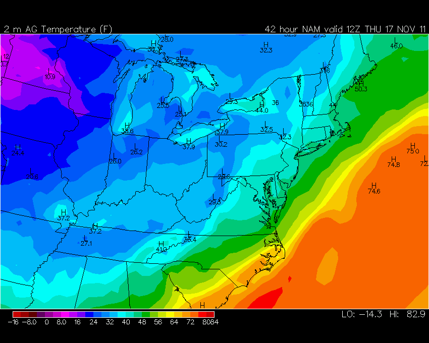
There is some question on Thursday morning lows - some clouds may hinder the temperatures from falling too fast - here is what the NAM model is showing for our local region - from www.wright-weather.com - click image for real view size (it is showing mostly 30s)
.

.
Also ran the SREF ensembles for temps - hovered over Massac County - you can see it makes an attempt to get down into the upper 20s and lower 30s on Thursday morning - either way somewhere in that range seems likely.
.

.
Fog will be possible on Tuesday and Wednesday night.
.
Windy conditions late in the week into the weekend.
.
Here are a couple of radar grabs of the storm as it moved through this area
.
Click image for large image view
.

.

.
.
Rain will continue into tonight (Tuesday night). Some heavy downpours not out of the question - especially over western Kentucky and western Tennessee. The bulk of the rain tonight (Tuesday night into Wednesday morning) will fall from Evansville, Indiana to Poplar Bluff - south and east of that line.
.
The best chance for rain tonight (Tuesday night) will be along a line from southwest Indiana into far southern Illinois and then back to Poplar Bluff - south and east of that line.
.
Rain will slowly end on Wednesday from west to east. There are some timing issues on exactly what time the rain ends in far western Kentucky and southern Illinois. Will at least keep rain in the forecast for the morning hours.
.
Cooler temperatures on Tuesday and Wednesday - we may see temperatures down into the upper 20s and lower 30s on Thursday and Friday morning. Most likely in the 28-34 degree range for southern Illinois and western Kentucky.
.
There is some question on Thursday morning lows - some clouds may hinder the temperatures from falling too fast - here is what the NAM model is showing for our local region - from www.wright-weather.com - click image for real view size (it is showing mostly 30s)
.
.
Also ran the SREF ensembles for temps - hovered over Massac County - you can see it makes an attempt to get down into the upper 20s and lower 30s on Thursday morning - either way somewhere in that range seems likely.
.

.
Fog will be possible on Tuesday and Wednesday night.
.
Windy conditions late in the week into the weekend.
.
.
.
We have a TON of new weather maps on the Weather Observatory web-site - these include temperatures, wind speed, dew points, heat index, barometric pressure, predicted rainfall, climate forecast, medium and long range maps, forecasts and more! Click here
.


 .
.
We have a number of new radars available on our Weather Observatory web-site!
---
We now offer St Louis, Mt Vernon, Evansville, Poplar Bluff, Cape Girardeau, Marion, Paducah, Hopkinsville, and Dyersburg Interactive City Radars. We also have the two regional radars and now offer you three GR Earth radars.
http://www.weatherobservatory.com/weather-radar.htm---
---
We also have a new interactive radar - you can view that radar by clicking here.
.
-----------------------------
.
.
Let's check out the how much rain is forecast to fall over the next 48 hours. This map gives you a general broad brushed idea of what can be expected. Remember the scale is at the top of the map.
.
.
If you would like to view the most up to date 24, 48, 72, and 120 hour precipitation forecast maps then click here.
.
Note the sharp cut off from the lighter to heavier totals.
.

.
Note the sharp cut off from the lighter to heavier totals.
.
.
.
You can also now view the probability of X amount of rain (you pick the value on the web-site) in a six hour period of time. Those maps can be viewed here.
.
You can view drought maps on the Weather Observatory web-site by clicking here
.

You can also now view the probability of X amount of rain (you pick the value on the web-site) in a six hour period of time. Those maps can be viewed here.
.
You can view drought maps on the Weather Observatory web-site by clicking here
.
.
.
Snow is not in our local forecast.
.
.
Snow is not in our local forecast.
.
.
Enhanced snowfall interactive forecast maps . You can choose your total snowfall amounts above the map - time frame, as well- click here
.
Snowfall forecast maps - these are interactive maps. You can choose your total snowfall amounts above the map - time frame, as well - click here
Enhanced snowfall interactive forecast maps . You can choose your total snowfall amounts above the map - time frame, as well- click here
.
Snowfall forecast maps - these are interactive maps. You can choose your total snowfall amounts above the map - time frame, as well - click here
.
If you are looking for wintry precipitation - click here.
.
.
You can view the upcoming days high temperature and low temperature forecasts by clicking here - choose the day - click on your state to zoom in
.
You can view the upcoming days high temperature and low temperature forecasts by clicking here - choose the day - click on your state to zoom in
.
.
. We have a number of new radars available on our Weather Observatory web-site!
---
We now offer St Louis, Mt Vernon, Evansville, Poplar Bluff, Cape Girardeau, Marion, Paducah, Hopkinsville, and Dyersburg Interactive City Radars. We also have the two regional radars and now offer you three GR Earth radars.
http://www.weatherobservatory.com/weather-radar.htm---
---
We also have a new interactive radar - you can view that radar by clicking here.
.
Want to learn more about how to use our radars? I made a how to video with more information
Click here - http://www.youtube.com/watch?v=bfLa0hI3adU
.
.
.
.
---

.
Date Range: November 20th -November 23rd
Event: Unsettled with several periods of showers and thunderstorms - locally heavy rain. Windy at times.
Severe Risk: Too soon to forecast severe weather.
Frozen Precipitation Risk: n/a
Details: Appears wet with several low pressure areas in the central United States
Confidence: Medium
Event: Unsettled with several periods of showers and thunderstorms - locally heavy rain. Windy at times.
Severe Risk: Too soon to forecast severe weather.
Frozen Precipitation Risk: n/a
Details: Appears wet with several low pressure areas in the central United States
Confidence: Medium
.
.
Date Range: November 25th -December 2nd
Event: Active weather pattern - we will be between the cold air to the north and warm air to the south - multiple storm systems may bring several chances for showers and thunderstorms - occasional shots of cold air - cold air is building in Canada. Expect several significant cold waves towards the end of the month into first part of December.
Severe Risk: Too soon to make a forecast on severe weather
Frozen Precipitation Risk: Unknown
Details: Potential for occasional shots of cold air with an active pattern - will be near the boundary of cold/warm air - plenty of chances for rain and possible thunderstorms.
Confidence: Low
.
.
Date Range: November 28th -December 10th
Event: Below normal temperatures.
Severe Risk:
Frozen Precipitation Risk: Unknown
Details: I continue to watch the cold air building up north - the pattern favors a dump of cold air towards the end of the month or into the beginning of December. Unsettled pattern overall for the next three weeks. Wet with numerous systems producing rain and thunderstorm chances.
Confidence: Low
.
.
.
Remember that as a general policy, in the long range outlook, I will NOT mention severe thunderstorms more than 72 hours in advance. I will mention thunderstorm risks and I will give as many details as possible. The word severe will be reserved for the short range forecast.
.
-----------------------------
.
1. I have made no significant changes in the long range outlook. Active and volatile pattern is underway.
.
Next system arrives late next weekend with more shower chances. Active pattern should continue for the next several weeks. That probably means more above normal temperatures with brief spells of colder weather.
.
Timing of the bigger push of colder air is still in question - thinking towards the end of the month into the first week of December.
.
Stronger and stronger temperature contrasts are showing up on the long range data - this helps fuel storms and is an indicator that I look for when considering storm intensity. Starting to see a winter pattern shape up - strong cold fronts - deeper lows.
.
Here is the latest 6 to 10 day outlook - this is for next Sunday through next Thursday - keep in mind that we will see above normal temperatures in front of storm systems and then below normal temperatures behind them. Cold will be transient in nature - as it has been the past few weeks. Warm warm - cool - warm warm - cool. Roller-coaster pattern. Typical of November for our region.
.

.
Here is the GFS from www.wrigh-weather.com for next Monday - gives you an idea on temperature contrast ahead and behind fronts. This is also a concern for severe weather. Something I will monitor - too soon to mention severe in the forecast. I reserve that for 72 hours in advance. Click image for full view size.
.

.
Next system arrives late next weekend with more shower chances. Active pattern should continue for the next several weeks. That probably means more above normal temperatures with brief spells of colder weather.
.
Timing of the bigger push of colder air is still in question - thinking towards the end of the month into the first week of December.
.
Stronger and stronger temperature contrasts are showing up on the long range data - this helps fuel storms and is an indicator that I look for when considering storm intensity. Starting to see a winter pattern shape up - strong cold fronts - deeper lows.
.
Here is the latest 6 to 10 day outlook - this is for next Sunday through next Thursday - keep in mind that we will see above normal temperatures in front of storm systems and then below normal temperatures behind them. Cold will be transient in nature - as it has been the past few weeks. Warm warm - cool - warm warm - cool. Roller-coaster pattern. Typical of November for our region.
.
.
Here is the GFS from www.wrigh-weather.com for next Monday - gives you an idea on temperature contrast ahead and behind fronts. This is also a concern for severe weather. Something I will monitor - too soon to mention severe in the forecast. I reserve that for 72 hours in advance. Click image for full view size.
.

.
Still watching for the NAO to head into negative territory - negative normally means colder weather for our region. End of the month/first part of December it should go negative.
.

.
Still watching for the NAO to head into negative territory - negative normally means colder weather for our region. End of the month/first part of December it should go negative.
.
.
November is looking as if it will be a bit of a roller coaster in the temperature department - if we do end up with several deep storm systems then we would experience warm air moving up ahead of the storms and then cold air behind the systems. Analogs are showing a cold to very cold December into February - with a cooler than average spring and stormy/wet spring. The cold air this winter will depend on the blocking - more blocking = colder weather.
.
Now is a GREAT time to buy a NOAA All Hazards Weather Radio. Better to have one before storms strike than to be without one during an event. I recommend the Midland Model 300 NOAA All Hazards Weather Radio - that is what I use here at my house!
.
Meteorologist Beau DodsonMcCracken County Office of Emergency Management
.

.
Beau Dodson Weather - Facebook
.

To view all watches and warnings in Illinois - Click Here
To view all watches and warnings in Kentucky - Click Here
To view all watches and warnings in Missouri - Click Here
To view all watches and warnings in Tennessee - Click Here
All other states- Click Here
. For the latest watches and warnings please visit your local National Weather Service Office web-sitehttp://www.weather.gov/organization.php
.
.
Remember most of these maps can be viewed straight off of the Weather Observatory Web-Site
.

.
No comments:
Post a Comment