Tuesday, November 30, 2010:
This site is non-profit and brought to you as a public service.
You can find more updates on my Facebook (under Beau Dodson) - Twitter, as well.
Bottom line it for me Beau...
For southern Illinois and far western Kentucky...
Severe or extreme weather risk for today, tonight, and tomorrow: 0%
Chance for freezing rain, sleet, or snow today, tonight, and tomorrow: A flurry or light snow shower is possible on Tuesday over west Kentucky and southern Illinois.
Today - Cloudy. Cold rain this morning. A chance for a flurry or light snow/sleet showers this afternoon. Temperatures steady or slowing falling through the day. Temperatures will be in the 30s by evening. West wind at 10-15 mph.
Tonight: Cloudy early this evening. Then becoming partly cloudy. Chilly. Low temperature around 27 degrees. West wind at 5 mph.
Wednesday: Partly cloudy. Cool. High temperature in the lower to middle 40s.
Your local National Weather Service seven day forecast can be viewed by clicking here.
Your regional and local radar - including precipitation type radar - click here.
Barometer reading this morning is in the 29.80-30.10" range. Last 24 hours of data - click here.
-----------------
Well, did you enjoy the rain? I received right at 1.50" here at my place. Most areas picked up between 0.70-1.50". A few spots had locally heavier rain. No severe weather was reported in our local counties. A few rumbles of thunder. A nice rain - much needed. We are trying to make up for the drought conditions over the last few months.
Showers continue this morning - I am receiving light rain here at my place - chilly rain. As temperature cool later today, I expect the rain showers to turn to a mixture of snow and sleet/pellets. No accumulation is forecast - more of a novelty event than anything. Just a reminder that winter is knocking on our door.
Areas across central and eastern Kentucky will remain under the main rain shield for several more hours - rain/thunderstorms - some heavy can be expected over that way. See Chris's discussion below for more information on that topic.
It appears the rest of the week will be fairly quiet. Another clipper type system will approach on Saturday night or Sunday - can not rule out some light precipitation. If the system does track further south - which is possible - then snow would be a possibility over much of the region - moisture is limited. However, these clipper type systems have a way of producing a quick burst of snow. We will keep an eye on that system. I will update accordingly..
Also watching a system for around December 6-8th. I have low confidence as to whether we will pick up precipitation from that event. The EC (model from Europe) wants to take the storm fairly far south. This would put us in a favorable area for mixed precipitation. However, I am just not confident enough to make a forecast call on that event. Ensembles are also all over the place.
We will keep an eye! Stay tuned.
Otherwise - enjoy your week.
- Meteorologist Beau Dodson
McCracken County Office of Emergency Management
Please visit Chris Bailey's weather blog if you live in central and eastern Kentucky http://www.kyweathercenter.com/
For the latest watches and warnings please visit your local National Weather Service Office http://www.weather.gov/organization.php
November 29, 2010: Rain is arriving - expect .75-1.50"
Monday, November 29, 2010:
This site is non-profit and brought to you as a public service.
You can find more updates on my Facebook (under Beau Dodson) - Twitter, as well.
Bottom line it for me Beau...
For southern Illinois and far western Kentucky...
Severe or extreme weather risk for today, tonight, and tomorrow: Less than 2%
Chance for freezing rain, sleet, or snow today, tonight, and tomorrow: A flurry possible on Tuesday over west Kentucky and southern Illinois.
Today - Cloudy. Rain and thunderstorms developing by late morning and becoming widespread this afternoon. Locally heavy downpours possible. Breezy. High temperatures near 56 degrees. Southeast winds at 10-15 mph with gusts to 30 mph on lakes and open areas.
Tonight: Cloudy. Rain in the evening. A rumble of thunder. Locally heavy rain possible in some counties. Breezy. Low temperature near 42 degrees. South/southwest winds at 10-15 mph. Gusts to 20 mph on lakes and open areas.
Tuesday: Rain ending early in the morning. A chance for a sprinkle or snow flurry during the afternoon and evening. Cooler with temperatures falling during the late morning and afternoon hours. High temperature near 45 degrees. West winds at 10-15 mph.
Tuesday Night: A few clouds. Cooler. Low temperatures near 28 degrees.
Your local National Weather Service seven day forecast can be viewed by clicking here.
Your regional and local radar - including precipitation type radar - click here.
Barometer reading this morning is in the 29.80-30.10" range. Last 24 hours of data - click here.
-----------------
Good morning everyone. We have a weather event underway as an area of low pressure pulls out of the central United States. This area of low pressure will help pull moisture northward today and produce widespread showers and thunderstorms over our region.
You can view all of the watches and warnings across the United States - click here.
Check out my regional radar (see link above) - it is already showing rain moving into the area. This will become more widespread through the day.

Severe weather is not expected - although a few strong to isolated severe storms could occur in Tennessee and areas to the south. At this time it does not appear that instability will be great enough for severe weather in Kentucky. As always listen to local media and NOAA Weather Radio for updates. The wind fields are very strong and it wouldn't take much to bring down a few gusty winds.
Also strong and gusty gradient winds are likely over our region (and areas to our east) through tonight. Gradient winds are winds caused by low pressure and high pressure - winds tighten up. Expect 30 mph gusts over our local region especially on lakes and open areas. I would not be surprised to see some 30-40 mph gusts across central and eastern Kentucky over the next 24-36 hour period.
Here is the latest NWS/HPC forecast rainfall totals for this next event (most of this will fall in the next 24 hours for our local counties and within the next 48 hours for the rest of Kentucky)

I am still expecting a widespread rainfall event in the 0.75" to 1.5" range. Some forecasts are calling for a bit more than that. Which might be possible - but as a general rule the above totals should be about right. Locally heavy amounts of 1.50-2.25" are certainly possible in areas that receive training thunderstorms (thunderstorms training over the same area for an extended period of time).
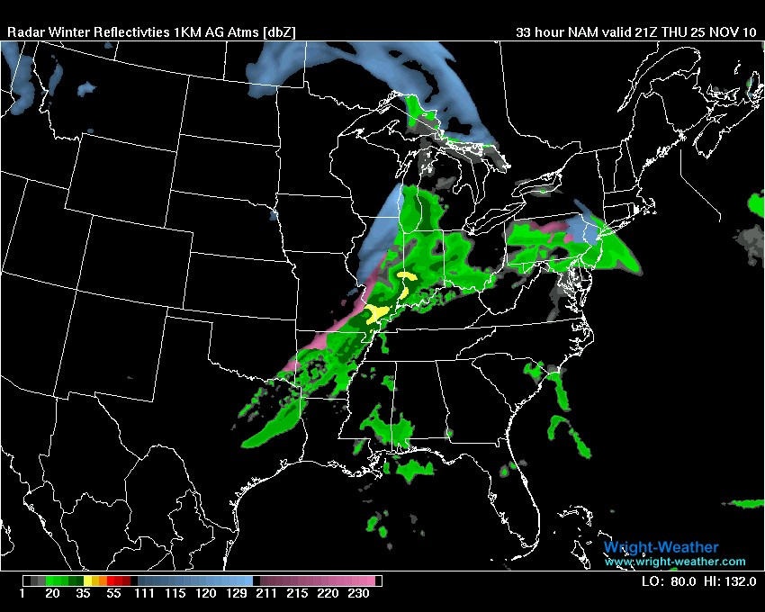
This is what the NAM (model) shows this evening for our region - this is supposed to be what radar would look like around 7-9 pm. These type of maps are never perfect - but you get the idea. This map is from my favorite source for maps - www.wright-weather.com - click image for a larger view.

Then let's take a look at tomorrow morning - between 4 am and 7 am - rain is moving to our east. I would not be surprised if there were still some showers a bit further west of what this model is predicting. But, again - you get the general idea.

Parts of Kentucky have been placed in a slight risk for excessive rainfall. This basically means that some heavy rainfall is expected and this could cause some problems with small stream and urban flooding. A lot of leaves are clogging drains, as well. This could cause some ponding of water.
The first map is for today and tonight and the second map is for tomorrow. Click all maps on this page for a larger view.


Here is the official severe weather outlook today - from the Storm Prediction Center. Note areas to our south are expecting some isolated severe storms. Emergency management officials in Kentucky should monitor for any updates - again, I don't expect any widespread severe weather. An isolated strong wind gust would be possible with any stronger storms.

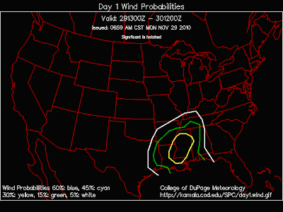
Let's also take a look at the probability maps for high winds and tornadoes - you can see that some severe weather is likely to our south and southeast. It will knock on Kentucky's door - so we will monitor.

Colder air will filter into our region on Tuesday. This colder air will mix with some wrap around moisture from the storm system and produce some sprinkles or even a flurry. Nothing significant is expected over our local counties.
Areas further north and east in Kentucky will need to monitor the timing of the change over. I would not be surprised to see some grassy surface accumulations in some areas. For those interested in weather further east in Kentucky then please see Chris Bailey's link at the bottom of the page.
The Transportation Cabinet should monitor this subject - especially over far northern Kentucky and far eastern Kentucky (a second ripple of low pressure will move up the boundary on Tuesday night and Wednesday). There are still some questions on how much precipitation will spread into the eastern portions of Kentucky from that system.
For the rest of the week...
A weak clipper type system will approach our local counties on Wednesday night and Thursday. At this time I am not overly optimistic that it will produce much of anything in the way of precipitation. But - will monitor. Areas to our north and east could experience a little bit of snow with that system - closer to Louisville and Cincinnati. Still a bit uncertain but worth watching.
Another system will approach our region over the weekend (see above) and again around December 7th. There is no general consensus on the track of the storm for the 6th-8th. Models have been hinting at a winter storm in the Ohio or Tennessee Valley. I posted about that subject yesterday - please see that discussion. However, I would not even dare take a guess this far out (and that is all it would be in this type of fast flow pattern).
So - we will just leave at a potential event. I will revisit this topic in the coming days.
I will give you a 90 day review tomorrow - we will look back at my fall forecast and how the 90 day period ended up.
Please have a safe week - enjoy the rain (we need all we can get).
- Meteorologist Beau Dodson
McCracken County Office of Emergency Management
Meteorological Adviser for the Kentucky Transportation Cabinet
Please visit Chris Bailey's weather blog if you live in central and eastern Kentucky http://www.kyweathercenter.com/
For the latest watches and warnings please visit your local National Weather Service Office http://www.weather.gov/organization.php
This site is non-profit and brought to you as a public service.
You can find more updates on my Facebook (under Beau Dodson) - Twitter, as well.
Bottom line it for me Beau...
For southern Illinois and far western Kentucky...
Severe or extreme weather risk for today, tonight, and tomorrow: Less than 2%
Chance for freezing rain, sleet, or snow today, tonight, and tomorrow: A flurry possible on Tuesday over west Kentucky and southern Illinois.
Today - Cloudy. Rain and thunderstorms developing by late morning and becoming widespread this afternoon. Locally heavy downpours possible. Breezy. High temperatures near 56 degrees. Southeast winds at 10-15 mph with gusts to 30 mph on lakes and open areas.
Tonight: Cloudy. Rain in the evening. A rumble of thunder. Locally heavy rain possible in some counties. Breezy. Low temperature near 42 degrees. South/southwest winds at 10-15 mph. Gusts to 20 mph on lakes and open areas.
Tuesday: Rain ending early in the morning. A chance for a sprinkle or snow flurry during the afternoon and evening. Cooler with temperatures falling during the late morning and afternoon hours. High temperature near 45 degrees. West winds at 10-15 mph.
Tuesday Night: A few clouds. Cooler. Low temperatures near 28 degrees.
Your local National Weather Service seven day forecast can be viewed by clicking here.
Your regional and local radar - including precipitation type radar - click here.
Barometer reading this morning is in the 29.80-30.10" range. Last 24 hours of data - click here.
-----------------
Good morning everyone. We have a weather event underway as an area of low pressure pulls out of the central United States. This area of low pressure will help pull moisture northward today and produce widespread showers and thunderstorms over our region.
You can view all of the watches and warnings across the United States - click here.
Check out my regional radar (see link above) - it is already showing rain moving into the area. This will become more widespread through the day.

Severe weather is not expected - although a few strong to isolated severe storms could occur in Tennessee and areas to the south. At this time it does not appear that instability will be great enough for severe weather in Kentucky. As always listen to local media and NOAA Weather Radio for updates. The wind fields are very strong and it wouldn't take much to bring down a few gusty winds.
Also strong and gusty gradient winds are likely over our region (and areas to our east) through tonight. Gradient winds are winds caused by low pressure and high pressure - winds tighten up. Expect 30 mph gusts over our local region especially on lakes and open areas. I would not be surprised to see some 30-40 mph gusts across central and eastern Kentucky over the next 24-36 hour period.
Here is the latest NWS/HPC forecast rainfall totals for this next event (most of this will fall in the next 24 hours for our local counties and within the next 48 hours for the rest of Kentucky)

I am still expecting a widespread rainfall event in the 0.75" to 1.5" range. Some forecasts are calling for a bit more than that. Which might be possible - but as a general rule the above totals should be about right. Locally heavy amounts of 1.50-2.25" are certainly possible in areas that receive training thunderstorms (thunderstorms training over the same area for an extended period of time).
This is what the NAM (model) shows this evening for our region - this is supposed to be what radar would look like around 7-9 pm. These type of maps are never perfect - but you get the idea. This map is from my favorite source for maps - www.wright-weather.com - click image for a larger view.

Then let's take a look at tomorrow morning - between 4 am and 7 am - rain is moving to our east. I would not be surprised if there were still some showers a bit further west of what this model is predicting. But, again - you get the general idea.

Parts of Kentucky have been placed in a slight risk for excessive rainfall. This basically means that some heavy rainfall is expected and this could cause some problems with small stream and urban flooding. A lot of leaves are clogging drains, as well. This could cause some ponding of water.
The first map is for today and tonight and the second map is for tomorrow. Click all maps on this page for a larger view.


Here is the official severe weather outlook today - from the Storm Prediction Center. Note areas to our south are expecting some isolated severe storms. Emergency management officials in Kentucky should monitor for any updates - again, I don't expect any widespread severe weather. An isolated strong wind gust would be possible with any stronger storms.

Let's also take a look at the probability maps for high winds and tornadoes - you can see that some severe weather is likely to our south and southeast. It will knock on Kentucky's door - so we will monitor.


Colder air will filter into our region on Tuesday. This colder air will mix with some wrap around moisture from the storm system and produce some sprinkles or even a flurry. Nothing significant is expected over our local counties.
Areas further north and east in Kentucky will need to monitor the timing of the change over. I would not be surprised to see some grassy surface accumulations in some areas. For those interested in weather further east in Kentucky then please see Chris Bailey's link at the bottom of the page.
The Transportation Cabinet should monitor this subject - especially over far northern Kentucky and far eastern Kentucky (a second ripple of low pressure will move up the boundary on Tuesday night and Wednesday). There are still some questions on how much precipitation will spread into the eastern portions of Kentucky from that system.
For the rest of the week...
A weak clipper type system will approach our local counties on Wednesday night and Thursday. At this time I am not overly optimistic that it will produce much of anything in the way of precipitation. But - will monitor. Areas to our north and east could experience a little bit of snow with that system - closer to Louisville and Cincinnati. Still a bit uncertain but worth watching.
Another system will approach our region over the weekend (see above) and again around December 7th. There is no general consensus on the track of the storm for the 6th-8th. Models have been hinting at a winter storm in the Ohio or Tennessee Valley. I posted about that subject yesterday - please see that discussion. However, I would not even dare take a guess this far out (and that is all it would be in this type of fast flow pattern).
So - we will just leave at a potential event. I will revisit this topic in the coming days.
I will give you a 90 day review tomorrow - we will look back at my fall forecast and how the 90 day period ended up.
Please have a safe week - enjoy the rain (we need all we can get).
- Meteorologist Beau Dodson
McCracken County Office of Emergency Management
Meteorological Adviser for the Kentucky Transportation Cabinet
Please visit Chris Bailey's weather blog if you live in central and eastern Kentucky http://www.kyweathercenter.com/
For the latest watches and warnings please visit your local National Weather Service Office http://www.weather.gov/organization.php
November 28, 2010: Another beautiful day then rain chances increase
November 27, 2010:
This site is non-profit and brought to you as a public service.
You can find more updates on my Facebook (under Beau Dodson) - Twitter, as well.
Bottom line it for me Beau...
For southern Illinois and far western Kentucky...
Severe or extreme weather risk for today: 0%
Severe or extreme weather risk for tonight: 0%
Severe or extreme weather risk for Monday: 0%
Chance for freezing rain, sleet, or snow today, tonight, and tomorrow: 0%
Today - BEAUTIFUL weather, once again! Sunny sky (few high clouds late in the day moving in from the southwest). High temperature near 54 degrees. Light winds.
Sunday night: Becoming cloudy. Milder. Low temperature near 40 degrees. Southeast winds at 5-10 mph.
Monday: Shower chances will increase through the day - spreading from the south/southwest towards the northeast. A chance for a rumble of thunder. Best rain chances will be in the afternoon. Warmer. Windier. High temperature near 58 degrees. South/southeast winds at 10-15 mph with gusts to 20 mph.
Monday Night: Rain - chance for thunder. Rain most widespread during the first half of the night. Low temperatures around 40 degrees. South winds at 10-15 mph - becoming westerly late.
Rainfall totals from Monday into Tuesday morning will generally be in the 0.75-1.50" range. Some locally higher amounts.
Your local National Weather Service seven day forecast can be viewed by clicking here.
Local and regional interactive radars can be viewed by clicking here.
Barometer reading this morning is in the 30.10-30.30" range. Last 24 hours of data - click here.
-----------------------
Well, good morning everybody. I hope you have had a wonderful holiday weekend! My family is getting together today to celebrate Thanksgiving. Everyone is coming over to my place - should be a lot of fun and a lot of food! Thankfully the weather is going to be nice today. So - I can have a break from watching the radar.
Our next storm chances are knocking at our door. An area of low pressure will push northward and northeastward over the next 24 hours and will spread rain and thunderstorms up and down the Mississippi and Ohio Valleys. This will make our fifth or sixth rainfall events over the last couple of weeks! November has turned active on us. I believe we can all be thankful for the much needed rainfall.
Expect widespread rainfall amounts in the 0.75-1.50" range. I would not be surprised to see some heavier amounts.
Severe weather is not expected. The Storm Prediction Center says we may see a few rumbles of thunder. Any severe weather risk should remain confined to Louisiana.
November has ended up being fairly quiet on the severe weather front. Nothing too extreme. A few small events. The extreme cold - arctic air has avoided us, as well. The last few days have not even been as cold as earlier cold spells. Again, nothing extreme.
A few maps for your weather eyes - this morning :)
These first two maps are the official forecasted rainfall totals for the next few days. The first map is the 5 day expected totals and the second map is for Monday/Tuesday. As you can see - most of our rain is going to fall tomorrow and Tuesday (basically nothing after that - for a few days). As always, you can click for a larger view.


Then let's break down what the NAM model is showing - this is from www.wright-weather.com My favorite location for viewing the latest computer guidance.

As you can see on the above map - radar is expected to show some showers starting to move into our region by late Monday morning and early afternoon. The coverage will increase through the day and evening hours. A few locally heavy showers are likely. Rain will be quite widespread by evening.

Then by late afternoon you can see that showers and a few thunderstorms will be fairly widespread over our region. Again, no severe weather is forecast.

The above map is from Monday evening - widespread showers and storms over our region. Mostly rain - a few thunderstorms.

The above image is the winter precip radar - these type of maps are never perfect. But they do provide us with a reasonable forecast map to gather an idea as to what to expect. You can see that no winter precipitation is expected in our region on Monday night. This image is for around 8-11 pm Monday evening.

Then the above map - Tuesday morning (around the 1-4 am time period). This shows showers and thunderstorms moving out of our region. There will likely still be a few showers left over - sprinkles/light rain. But the bulk of the precipitation will have moved east of western Kentucky.

Around 7 am on Tuesday morning - areas to our east can expect rain to continue. Central and eastern Kentucky will have a wet Tuesday.

Tuesday - late morning - the above map shows precipitation continuing to our east. We may still have a little bit of moisture left over in our region (southern Illinois and western Kentucky). This could provide an opportunity for a few sprinkles or even a flurry here and there. Nothing major or significant.
The best chance for snow and snow showers with this system will be across eastern Kentucky later on Tuesday night and Wednesday - some left over moisture should help produce some change over to snow on the backside of the storm. Those "snow" favored areas should be in line for at least some snow showers. The climate in central and eastern Kentucky is nothing like the climate here in western Kentucky. I like to refer to Chris Bailey on eastern areas.
The next storm system I am watching will occur around December 5-7th. We have been talking about that particular storm for about 2 weeks now. There are still a lot of questions that remain on the table as to the impact for our region - if any. It is just too far out to make a call. But, something I am watching.
If you remember - I use ensembles to look at storms down the road. An ensemble is the same computer model but tweaked a little bit differently each time they run it. This is supposed to give us a better of idea on how a forecast might unfold - how a pattern might unfold. You have to be careful how you use ensembles - there is more to it than just what the map shows. Models are simply guidance to help us figure out the forecast - they often times are not correct and need to be tweaked.
Anyway, here is what December 6th is showing - some rain? Some snow? Some ice? Nothing at all. :) Ahhh - the fun of forecasting. Stay tuned. We will keep an eye on this event. There is the potential for a significant winter precipitation event over the central and eastern United States during the December 5-7th time period (but again - this is was too far out to know how the storm will unfold - if there is a storm at all) - we may need to adjust the dates a bit (could be a day or two later). Still plenty of time to watch the storm.

Here is what the GFS is showing for that same time period - this is a major winter storm for the Ohio Valley and perhaps even further south. Extreme caution should be used with the GFS - it has not done well with the cold air this fall season. For weeks it has been showing extreme solutions - with almost no verification. I have little faith in the temperature output from the GFS past day four and five. But, again - this is something we will just have to monitor. Models do not do well with seasonal transitions or past day four or five.

Something for the Transportation Cabinet and others to be watching.
Have a WONDERFUL and sunny Sunday!
- Meteorologist Beau Dodson
McCracken County Office of Emergency Management
Please visit Chris Bailey's weather blog if you live in central and eastern Kentucky http://www.kyweathercenter.com/
For the latest watches and warnings please visit your local National Weather Service Office http://www.weather.gov/organization.php
November 27, 2010: Rain is coming - rain is coming :)
November 27, 2010:
This site is non-profit and brought to you as a public service.
You can find more updates on my Facebook (under Beau Dodson) - Twitter, as well.
Bottom line it for me Beau...
For southern Illinois and far western Kentucky...
Severe or extreme weather risk for today: 0%
Severe or extreme weather risk for tonight: 0%
Severe or extreme weather risk for Sunday: 0%
Chance for freezing rain, sleet, or snow today, tonight, and tomorrow: 0%
Today - BEAUTIFUL weather! Sunny sky. High temperature near 47 degrees. Light winds.
Tonight: Another great night for star gazing. Cool. Low temperature near 28 degrees. Light winds.
Sunday: Mostly sunny - increasing high clouds late in the day. Warmer. High temperature near 55 degrees.
Sunday night: Becoming cloudy. Milder. Low temperature near 40 degrees.
Monday: Shower chances will increase through the day. Warmer. Windier. High temperature near 58 degrees. South winds at 10-15 mph with gusts to 20 mph.
Rainfall totals from Monday into Tuesday morning will generally be in the 0.75-1.50" range. Some locally higher amounts.
Your local National Weather Service seven day forecast can be viewed by clicking here.
Local and regional interactive radars can be viewed by clicking here.
Barometer reading this morning is in the 30.10-30.30" range. Last 24 hours of data - click here.
-----------------------
A BEAUTIFUL weekend is on tap for our region. As you can see outside your window this morning - plenty of sunshine. Got to love this late November weather. No extreme cold or severe weather. Normal temperatures for our region. Arctic air is well to our north - so we don't have to worry about that subject for the time being.
RAIN is heading our way - once again. I believe this makes the 5th or 6th event in the last two or three weeks. Our active late November weather continues. We need the rain - so no complaints, please!
Here is a look at the official 5 day rainfall total forecast from HPC/NWS. I believe most of us will see 0.75"-1.50". Some locally higher amounts are possible.


The above map is the NAM forecast map for Monday afternoon. You can see showers already moving into portions of our region at that time. Expect showers to become more numerous during the afternoon and evening hours. A rumble of thunder is possible. I am not expecting severe weather. Click images for larger view, as always. Images are from my favorite model web-site www.wright-weather.com

The above map is for around 8 or 9 pm on Monday evening. Lot of rain in our region.

And here we go on Tuesday morning - see the pink/purples moving away. That is the cold front pushing east of our region. This will end our rain chances.
I am not expecting any snow with this system in western Kentucky. Eastern Kentucky may have a brief mix or change over - snow showers.
The next system I am watching will arrive or approach our region around December 6th. Too far out for predictions. I have been watching that system for some time now.
Enjoy your holiday weekend!
- Meteorologist Beau Dodson
McCracken County Office of Emergency Management
Please visit www.weatherobservatory.com for more information
Please visit Chris Bailey's weather blog if you live in central and eastern Kentucky http://www.kyweathercenter.com/
For the latest watches and warnings please visit your local National Weather Service Office http://www.weather.gov/organization.php
November 26, 2010: A break from the wild weather for a few days!
November 26, 2010:
This site is non-profit and brought to you as a public service.
You can find more updates on my Facebook (under Beau Dodson) - Twitter, as well.
Bottom line it for me Beau...
For southern Illinois and far western Kentucky...
Severe or extreme weather risk for today, tonight, and tomorrow: 0%
Chance for freezing rain, sleet, or snow today, tonight, and tomorrow: 0%
Today - Sunny and cooler. High temperature near 47 degrees. West winds at 10 mph.
Tonight: Clear. Cold. Low in the upper 20s. Light winds.
Saturday: Sunny. Cool. Highs in the upper 40s. Light winds.
Saturday Night: Clear - nice start watching weather. Lows in the upper 20s.
Sunday - Increasing high clouds late in the day - otherwise sunny. A bit milder. Highs near 55 degrees. Southeast wind at 5-10 mph.
Your local National Weather Service seven day forecast can be viewed by clicking here.
Barometer reading this morning is in the 30.10-30.30" range. Last 24 hours of data - click here.
-----------------------
Check out the temperature graph from my place on Thursday. That was quite a drop. We fell 20 degrees in about 15 minutes. We reached a high of 70! We were in the 20s last night. We had thunderstorms, heavy rain, strong winds over 40 mph, and sleet/snow! What a ride.

Next rain and storm chances arrive on Monday and Monday night.
Here is what the www.wright-weather.com GFS model is showing - this looks about right to me. Expect widespread .25-1.20" of rain across the region. Could be a rumble of thunder. Not expecting severe weather - will monitor, as always.

Also - let's take a look at the rainfall maps for the last 24 hours.


Enjoy your weekend!
- Meteorologist Beau Dodson
McCracken County Office of Emergency Management
For the latest watches and warnings please visit your local National Weather Service Office http://www.weather.gov/organization.php
November 25, 2010: No change in forecast
November 25, 2010:
FLOOD WARNINGS ARE BEING ISSUED FOR SOME COUNTIES - Heavy rainfall is possible in some counties today. Please check your local NWS Office (see link at the bottom of this post) for the latest watches and warnings.
Well forecast event is underway. No changes in the forecast - other than increasing expected totals slightly. See yesterdays comments.
Latest forecasted rainfall totals from NWS/HPC - click for larger image

Rain is moving into the region - locally heavy at times. Additional rainfall totals - widespread - of 0.50"-1.50" will likely occur through this afternoon. Local amounts will exceed 2-3". Some flooding is possible on roadways. Please avoid flooded roadways. Warm this morning and turning colder this afternoon. Rain will change to a light mix of sleet and snow later this evening and tonight. No accumulation is expected - there could be some slick spots on bridges and overpasses.
Here is the forecast temperature drop for Paducah, Bowling Green, and Lexington - click image for larger view


For those of you further east in Kentucky - please check out Chris Bailey's information - click here.
A flood watch is in effect for portions of the region. Also a winter weather advisory for portions of Missouri, Arkansas, and Tennessee.
Your seven day forecast - click here.
Your regional and local radar - click here.
Temperatures will fall into the 20s tonight!
Let's track the cold air on the NAM model - this should give a pretty good idea of how this will advance across our area and local states.
These images are in zulu time - 0z Friday would be around 6-7 pm tonight. Click for larger images. These images are all from www.wright-weather.com - my choice for model information.


Next storm system will arrive on Monday and another one around the 5-7th of December.
I am forecasting a cold December - with below normal temperatures.
Hope everyone has a HAPPY THANKGIVING!
- Meteorologist Beau Dodson
McCracken County Office of Emergency Management
For the latest watches and warnings please visit your local National Weather Service Office http://www.weather.gov/organization.php
November 24, 2010: Rain and storms - brief period of frozen precip
November 22, 2010:
This site is non-profit and brought to you as a public service.
You can find more updates on my Facebook (under Beau Dodson) - Twitter, as well.
Bottom line it for me Beau...
For southern Illinois and far western Kentucky...
Severe or extreme weather risk for today: 0%
Severe or extreme weather risk for tonight: Slight chance for isolated severe storms
Severe or extreme weather risk for Thanksgiving Day - Slight risk during the morning hours.
Here is your morning radar - click here.
Freezing rain, sleet, or snow today, tonight, and tomorrow risk probabilities: 0% today, 0% tonight, and a good chance (60%) for a light mix of sleet and snow on Thursday afternoon or evening. No accumulation is expected.
A flood watch has been issued for portions of the region - please check your local NWS forecast office for additional information.
Wednesday: A period of chilly showers - possible thunderstorms this morning. Then a lull in the precipitation. High temperatures near 60 degrees.
Wednesday night: A chance for showers in the evening. Showers and thunderstorms becoming likely after midnight. A few strong storms will be possible. Temperatures steady or slowly rising. Breezy.
Thanksgiving: Cloudy with showers and thunderstorms likely. Rain may end as a brief period of mixed precipitation (sleet/snow/freezing rain). No accumulation is expected. High temperatures early in the day and then temperatures falling in the late afternoon (there is some disagreement among models on exactly what time the front will move through). High near 65-70 early and then temperatures falling into the 30s during the late afternoon period. Windy.
Thanksgiving night: Cloudy with a good chance for a mix of rain, sleet, and snow. Possibly a light period of freezing rain. No accumulation is expected. Windy. Temperatures falling into the 20s. Watch for slick spots on bridges and overpasses.
As you travel on Thursday and Thursday night please remember that bridges and overpasses can have slick spots on them much faster than other roadways. Any moisture left on pavement could freeze.
Rainfall totals (from last nights rain through Thursday night) across southern Illinois and western Kentucky from today into Friday will be in the 1-2" range with some higher amounts possible. Rainfall in the State of Kentucky will likely be in the 1.5-3.5" range. Again locally higher amounts are forecast - especially along the Ohio River Counties.
Here is the map from the NWS/HPC on forecasted rainfall totals. Note the heavy amounts in red.

Your local National Weather Service seven day forecast can be viewed by clicking here.
This is a complicated forecast and I would advise everyone to listen for updates. I will update the blog if changes are needed. Also check my Facebook posts.
Local and regional interactive radars can be viewed by clicking here.
Barometer reading this morning is in the 29.80-30.10" range. Last 24 hours of data - click here.
-----------------------
If you need to view forecasts for other areas or watches/warnings then click here.
Well forecasted event is underway. Precipitation has spread across our entire region this morning. Locally heavy showers and storms are being reported. As you travel north the precipitation is falling the form of a mixture of sleet and snow. Use caution.
The warm front will pass through our region today and this will usher in warmer air. Expect temperatures tonight to actually hold steady or rise. This will be a signal that additional showers and thunderstorms will be likely during the overnight hours and again on Thanksgiving Day.
Isolated strong or severe storms can not be ruled out later tonight and on Thursday morning before the cold front passes through our counties. You can view the official Storm Prediction Center outlook by clicking here.
A SHARP temperature drop will accompany the front. Temperatures could fall 20-30 degrees in just a few hours.
Here is a chart for Paducah, KY - this shows just how fast the temperature will fall on Thursday.

The precipitation will quickly change over to sleet and snow on Thursday afternoon and evening. Some light freezing rain is also possible. No accumulation is forecast. However, bridges and overpasses could have a few slick spots - especially if the sleet comes down at a faster rate than expected. I will monitor - but just use caution, as always.
Here is another map that shows the sharp temperature contrast across our region tomorrow morning at 7 a.m. Click for larger view - this image is from www.wright-weather.com

Then tomorrow afternoon (the map below) - you can see the cold air moving in from the west.

Then let's take a look at tomorrow evening - you can see the cold air pushing even further into Kentucky. This would be around 6-8 pm. There are some questions on the exact speed of the front. If it moves in faster then we may have to move up the time of arrival. But - you at least get the general idea of what we are looking at. Rain - lots of rain - then cold air quickly moves in and changes the precip to a light period of mixed precip.
Again - this map is tomorrow evening. Click for a large view. The map is from www.wright-weather.com Where I get most of my model data.

Here is how one model sees the changeover on Thanksgiving Day - the blue is snow - pink/red is sleet or mixed precip. Again, no significant accumulation is forecast.
This map is for around noon tomorrow - that area if mixed precip will spread east with time.

Then around 2 pm tomorrow afternoon - this is how the NAM believes the radar will appear. Again - click all images for a larger view. The radar images are from www.wright-weather.com

Then finally - these last two maps are for Thursday evening (ignore where it says Friday - that is in Zulu time). This would be around 5-8 pm tomorrow evening. You can see the little area of changeover at the end.

Thursday evening - late. Again - this might not be exactly how the radar will look. This is a model forecast. The blue area is snow or a mix of precipitation.

Friday into Saturday/Sunday will be dry. Colder. The next chance for precipitation will arrive on Monday and Tuesday. Thunderstorms are possible.
Also - for those further east in Kentucky - please visit Chris Bailey's forecast thoughts - click here.
Hope everyone will have a safe holiday!
- Meteorologist Beau Dodson
McCracken County Office of Emergency Management
For the latest watches and warnings please visit your local National Weather Service Office http://www.weather.gov/organization.php
This site is non-profit and brought to you as a public service.
You can find more updates on my Facebook (under Beau Dodson) - Twitter, as well.
Bottom line it for me Beau...
For southern Illinois and far western Kentucky...
Severe or extreme weather risk for today: 0%
Severe or extreme weather risk for tonight: Slight chance for isolated severe storms
Severe or extreme weather risk for Thanksgiving Day - Slight risk during the morning hours.
Here is your morning radar - click here.
Freezing rain, sleet, or snow today, tonight, and tomorrow risk probabilities: 0% today, 0% tonight, and a good chance (60%) for a light mix of sleet and snow on Thursday afternoon or evening. No accumulation is expected.
A flood watch has been issued for portions of the region - please check your local NWS forecast office for additional information.
Wednesday: A period of chilly showers - possible thunderstorms this morning. Then a lull in the precipitation. High temperatures near 60 degrees.
Wednesday night: A chance for showers in the evening. Showers and thunderstorms becoming likely after midnight. A few strong storms will be possible. Temperatures steady or slowly rising. Breezy.
Thanksgiving: Cloudy with showers and thunderstorms likely. Rain may end as a brief period of mixed precipitation (sleet/snow/freezing rain). No accumulation is expected. High temperatures early in the day and then temperatures falling in the late afternoon (there is some disagreement among models on exactly what time the front will move through). High near 65-70 early and then temperatures falling into the 30s during the late afternoon period. Windy.
Thanksgiving night: Cloudy with a good chance for a mix of rain, sleet, and snow. Possibly a light period of freezing rain. No accumulation is expected. Windy. Temperatures falling into the 20s. Watch for slick spots on bridges and overpasses.
As you travel on Thursday and Thursday night please remember that bridges and overpasses can have slick spots on them much faster than other roadways. Any moisture left on pavement could freeze.
Rainfall totals (from last nights rain through Thursday night) across southern Illinois and western Kentucky from today into Friday will be in the 1-2" range with some higher amounts possible. Rainfall in the State of Kentucky will likely be in the 1.5-3.5" range. Again locally higher amounts are forecast - especially along the Ohio River Counties.
Here is the map from the NWS/HPC on forecasted rainfall totals. Note the heavy amounts in red.

Your local National Weather Service seven day forecast can be viewed by clicking here.
This is a complicated forecast and I would advise everyone to listen for updates. I will update the blog if changes are needed. Also check my Facebook posts.
Local and regional interactive radars can be viewed by clicking here.
Barometer reading this morning is in the 29.80-30.10" range. Last 24 hours of data - click here.
-----------------------
If you need to view forecasts for other areas or watches/warnings then click here.
Well forecasted event is underway. Precipitation has spread across our entire region this morning. Locally heavy showers and storms are being reported. As you travel north the precipitation is falling the form of a mixture of sleet and snow. Use caution.
The warm front will pass through our region today and this will usher in warmer air. Expect temperatures tonight to actually hold steady or rise. This will be a signal that additional showers and thunderstorms will be likely during the overnight hours and again on Thanksgiving Day.
Isolated strong or severe storms can not be ruled out later tonight and on Thursday morning before the cold front passes through our counties. You can view the official Storm Prediction Center outlook by clicking here.
A SHARP temperature drop will accompany the front. Temperatures could fall 20-30 degrees in just a few hours.
Here is a chart for Paducah, KY - this shows just how fast the temperature will fall on Thursday.

The precipitation will quickly change over to sleet and snow on Thursday afternoon and evening. Some light freezing rain is also possible. No accumulation is forecast. However, bridges and overpasses could have a few slick spots - especially if the sleet comes down at a faster rate than expected. I will monitor - but just use caution, as always.
Here is another map that shows the sharp temperature contrast across our region tomorrow morning at 7 a.m. Click for larger view - this image is from www.wright-weather.com

Then tomorrow afternoon (the map below) - you can see the cold air moving in from the west.

Then let's take a look at tomorrow evening - you can see the cold air pushing even further into Kentucky. This would be around 6-8 pm. There are some questions on the exact speed of the front. If it moves in faster then we may have to move up the time of arrival. But - you at least get the general idea of what we are looking at. Rain - lots of rain - then cold air quickly moves in and changes the precip to a light period of mixed precip.
Again - this map is tomorrow evening. Click for a large view. The map is from www.wright-weather.com Where I get most of my model data.

Here is how one model sees the changeover on Thanksgiving Day - the blue is snow - pink/red is sleet or mixed precip. Again, no significant accumulation is forecast.
This map is for around noon tomorrow - that area if mixed precip will spread east with time.

Then around 2 pm tomorrow afternoon - this is how the NAM believes the radar will appear. Again - click all images for a larger view. The radar images are from www.wright-weather.com
Then finally - these last two maps are for Thursday evening (ignore where it says Friday - that is in Zulu time). This would be around 5-8 pm tomorrow evening. You can see the little area of changeover at the end.

Thursday evening - late. Again - this might not be exactly how the radar will look. This is a model forecast. The blue area is snow or a mix of precipitation.

Friday into Saturday/Sunday will be dry. Colder. The next chance for precipitation will arrive on Monday and Tuesday. Thunderstorms are possible.
Also - for those further east in Kentucky - please visit Chris Bailey's forecast thoughts - click here.
Hope everyone will have a safe holiday!
- Meteorologist Beau Dodson
McCracken County Office of Emergency Management
For the latest watches and warnings please visit your local National Weather Service Office http://www.weather.gov/organization.php
November 23, 2010: Overnight rains moving out - more to develop
November 22, 2010:
This site is non-profit and brought to you as a public service.
You can find more updates on my Facebook (under Beau Dodson) - Twitter, as well.
Bottom line it for me Beau...
For southern Illinois and far western Kentucky...
Severe or extreme weather risk for today: 0%
Severe or extreme weather risk for tonight: 0%
Chance for freezing rain, sleet, or snow today, tonight, and tomorrow: 0%
Today - Morning rain will come to an end. Cloudy early in the day. Then becoming partly sunny. Cooler. High temperature near 56 degrees. West to Northwest winds at 10 mph.
Tonight: Increasing clouds. A shower possible late. Low temperature in the upper 30s. Southeast winds at 10 mph.
Wednesday: A period of showers - possible thunderstorms. Then a lull in the precipitation. High temperatures near 60 degrees.
Wednesday night: A chance for showers in the evening. Showers and thunderstorms becoming likely after midnight. A few strong storms will be possible. Temperatures steady or slowly rising. Breezy.
Thanksgiving: Cloudy with showers and thunderstorms likely. Rain may end as a brief period of mixed precipitation. High temperatures early in the day and then temperatures falling in the late afternoon (there is some disagreement among models on exactly what time the front will move through). High near 65-70 early and then temperatures falling into the 30s during the late afternoon period. Windy.
As you travel on Thursday and Thursday night please remember that bridges and overpasses can have slick spots on them much faster than other roadways. Any moisture left on pavement could freeze.
Rainfall totals (from last nights rain through Thursday night) across southern Illinois and western Kentucky from Monday afternoon into Friday will be in the 1-2" range with some higher amounts possible. Rainfall in the State of Kentucky will likely be in the 1.5-3.5" range.
Your local National Weather Service seven day forecast can be viewed by clicking here.
This is a complicated forecast and I would advise everyone to listen for updates. I will update the blog if changes are needed. Also check my Facebook posts.
Local and regional interactive radars can be viewed by clicking here.
Barometer reading this morning is in the 30.10-30.30" range. Last 24 hours of data - click here.
-----------------------
I am not overly excited about the prospect of winter weather across western Kentucky with the Thanksgiving storm. But, it is something we will monitor.
Some colder air will move into the region on Thursday into Saturday - but nothing unusual. Lows will be in the 20s over western Kentucky. The cold will be transient in nature - meaning it will already start warming up by Saturday and Sunday!
I did grab this forecast map from the NAM (model). You can see the impressive temperature gradient along the front. Cold air will be moving into our region on Thursday. Click image for larger image. This map is from www.wright-weather.com


Let's take a look at what that would look like on a graph. This is impressive! This is Paducah, Kentucky - temperature graph. Note the peak before the front moves through. Then the rapid drop.

I am a bit concerned about at least some isolated severe weather on Wednesday night and Thursday over our local region - mostly to our west. We will see what SPC (Storm Prediction Center) has to say in their morning update and afternoon updates. This is one part of the forecast that we will need to update and monitor.
The SPC has placed a slight risk for severe storms to our west on Wednesday. This may need to be updated and shifted eastward - right now the main threat appears to be to our west. However, for now this is the current map forecast from the Storm Prediction Center. This is the probability map.

Don't forget you can also check Chris Bailey's forecast updates - click here.
I am watching another storm system for next Monday and Tuesday - that is in the long range. Plenty of time to watch that system. Colder weather will once again follow that storm system.
Also watching a system for around December 5-7th. Long way off - but keeping an eye on the potential for a winter storm in the central United States.
- Meteorologist Beau Dodson
McCracken County Office of Emergency Management
For the latest watches and warnings please visit your local National Weather Service Office http://www.weather.gov/organization.php
Subscribe to:
Posts (Atom)